Chāh ba Chāh: The Technique of Water-lifting at Fathpur Sikri

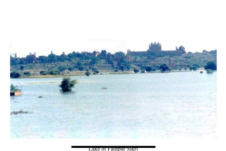
The real feat of hydraulic engineering at Fathpur Sikri is revealed in the elaborate system of lifting the water from the ground level to the top of the ridge where the palace

complex, the nobles’ quarters and houses of the main civic population were located.

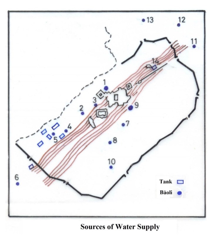
A survey of Fathpur Sikri reveals that the imperial system of water-supply was divided into two sections – the Northern water works, situated near the Hāthipol and the

Southern Water works, near the Hakim’s Baths. These water works, were apparently designed to meet the entire need for water in the Palace Complex as well as the town of Fathpur Sikri.

Northern Waterworks

The Northern Water Works appear to be more elaborate and technically sophisticated. We are fortunate that Peter Mundy gives a very precise description:

The kings’ howse or Moholl stands on the highest hill, within which are aboundance of Courts, Conveyances, galleries, chowtrees (chabūtara) , Arches, pillars, Tancks, Chaboochaees (Chāhbacha), private roomes, all yery rich, curious, and full of invention of painteinge, carvinage, etts; also a little garden. The water to water it is also to fill the Tancks alofte, and for their use is drawne from the valley, first into one Tanck and then from that into another higher, and soe into 4 or 5 untill it came alofte, by that which wee in Spaine call Noraies.

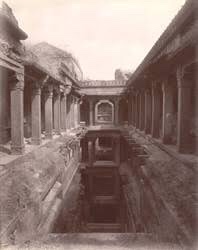
At the first stage, the subterraneous water was raised through the construction of an octagonal bāoli below the Hathipol. This bāoli is shaped in the form of an irregular

octagon, a chamfered square, with each of the principal sides measuring 15.45 metres.

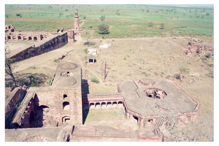
The chamfered sides of the octagon have lengths of 4.60 m. In the middle of this structure is an octagonal well with each side 2.90 m in length. To the north and south of the well are placed two octagonal chambers, the raised vaulted ceilings of which are visible as octagonal platforms from above. A 0.23 m – wide water channel carried the water from this bāoli to an artificial well situated to its west. This water channel runs on top of a 12.15m long and 2.55 m broad aqueduct.

The artificial well (chāh ba chāh, more popularly, chāh-bachcha, receiving water from another well) which acted as the second stage for lifting water is a rectangular structure with two vaulted chambers flanking the circular well on two sides. The well itself is 10.6 m deep and 3.96 m in diameter. From here a water channel (0.23m in width) took the water to a second storage well, which again is flanked by two vaulted chambers. Between the two storage wells, the water was carried to an approximate distance of 10.50 m.

The water brought to this second storage tank was then lifted to a large rectangular tank situated towards the south.

A water channel then emptied the water into another rectangular trough constructed at the level of the floor of the Hathipol. Until this stage the water was raised to an approximate height of 30 meters from the ground level.

Just above the water trough are constructed projecting spaces to further raise the water to the fourth stage atop the roof of the quadrangle to the east of the Hathipol. A set of aqueducts diverted the water from this roof to the two storage tanks constructed on the first floor of the structure flanking the second Gateway after the Hathipol.

From here the water was again raised to a fifth stage, and, through a channel running atop the gateway entered the haramsara complex through the north-western corner of the so-called “Birbals’ House” quadrangle (the first Imperial Palace) .

Another branch of the water channel took the water through the northern walls of the Hathipol daftarkhana to the bureaucratic establishments constructed below the hauz-i Shirin.

Water-lifting Devices

A question which arises at this stage is, how the water was raised to the succession of the chāhbachāhs. We have already quoted Peter Mundy wherein he mentions the use of ‘Noraies’. Bishop Heber visited Fathpur Sikri In 1825 AD.

Describing the water works, although confusing its location and attributing it to be adjoining the Jami Masjid, he writes:

… and the whole hill on which the palace stands bears marks of terraces and gardens, to irrigate which an elaborate succession of wells, cisterns, and wheels appears to have been contrived adjoining the great mosque, and forcing up the water nearly to the height of its roof. The cisterns are still useful as receptacles for rain-water, but the machinery is long since gone to decay.

Evidence from Miniatures

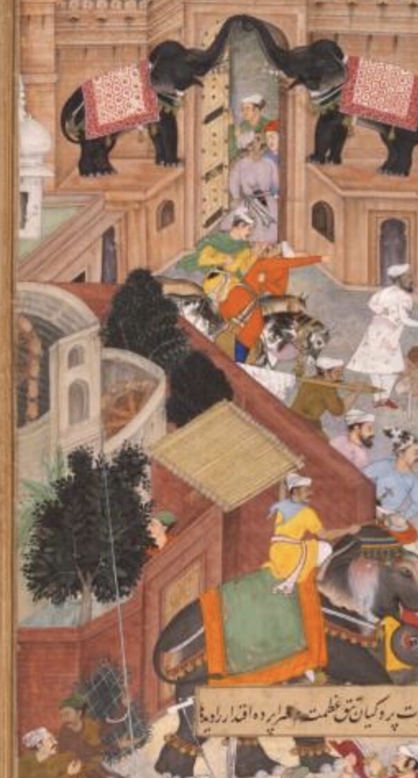
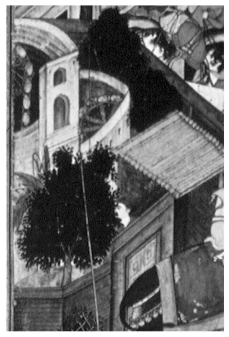
Two Akbarnama paintings depict this water lifting device which was used to raise the water in the northern water works. (See plates 1&2) The first miniature, which was

designed (or outlined; tarah) by Tulsi and painted ( amal ) by Bhawani, depicts a Persian wheel drawing water from a well near the Hathipol, which is under construction.

The second depicts Persian wheels at two stages near the Hathipol.

The Persian wheel, as we know, was a device which was based on the technique of pin-drum gearing. It comprised of a wheel, fixed on the mouth of the well, which contained a string of pots (māla). This wheel atop the well was connected with a second wheel through a shaft. The second wheel fitted with wooden pegs (pins) was rotated

vertically by horizontally rotating a pin drum (i.e. a double-drum, whose two layers are joined at the rim by pegs placed at the same distance as on the rim of the other wheel.

The horizontal motion to the drum was provided through draught animals harnessed to it through a shaft. According to Abul Fazl Akbar had invented a way of raising water to a

great height from a low level through the water wheel. To quote:

His majesty made such water wheels (daulāb-ha), and such (gear) wheel (gardūn-ha) were fixed thereon, that water may be carried to a height from distant low-lying places.

This was due to his placing the pin-drum at much higher level than the draw bar of the oxen turning round the axle. This meant that the water would be drawn up through

the chain of pots to a height considerably above the oxen, where the mouth of the receiving aqueduct could now be placed. It happens that two paintings in Nizami’s Khamsa prepared in Akbars atelier illustrate such a device.

A closer took at the octagonal bāoli of the Northern water works and its storage wells reveals the provision of stone shafts which once held the vertically rotating wheel of pots. The draw-bars which rotated this wheel were placed in the two vaulted chambers, which we have noted flanked the well in the bāoli and the two storage wells. Similarly, protruding stone beams fixed atop the rectangular cavities near the Hathipol lifted the water atop the roof of the eastern quadrangle. Thus we see that the Northern waterworks was a complex of storage tanks, storage wells and Persian wheels which helped the water to be raised at five stages to reach the level of the Imperial complex atop the ridge.

The Southern Waterworks

The Southern water-works which centred around the bāoli attributed to Shah Quli, near the Hakim’s Baths, survives in a much more dilapidated condition. From here the water was supplied not only to the daulatkhāna but also to the civic population living in the areas south of the ridge.

Shah Quli’s bāoli appears to be the largest step well at Fathpur Sikri and comprises three storeys surrounding the octagonal well. Water drawn from this step well with the cutlasses fixed in the two chambers adjoining the well was carried through ducts to a raised storage tank situated in front of the Hakim’s Baths. From here the Persian wheels lifted the water, which was then distributed through aqueducts into three directions, the north, east and west. In the north, the water emptied into a tank situated near the massive ‘Sukh tāl’ adjacent to the Imperial Baths, from where it was taken to the Baths and garden of the daulatkhana.

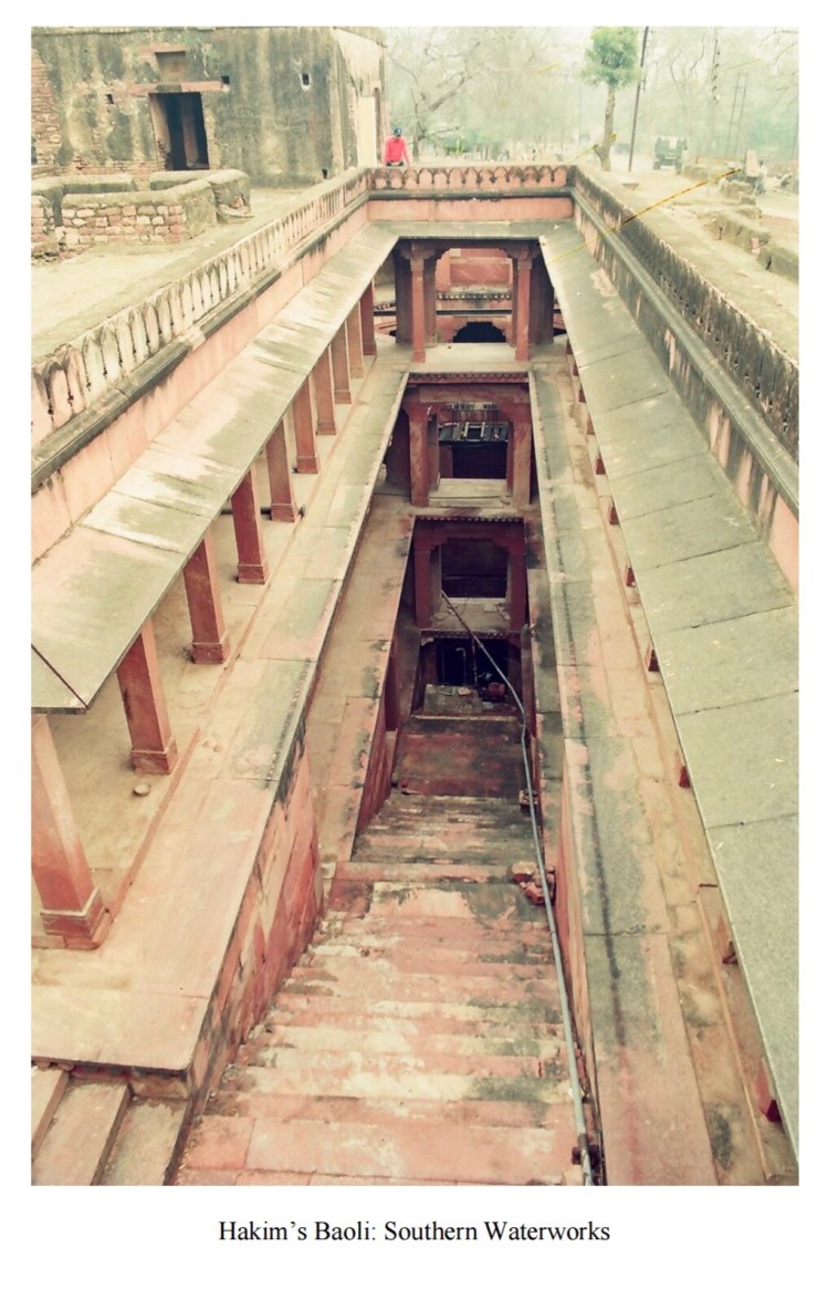
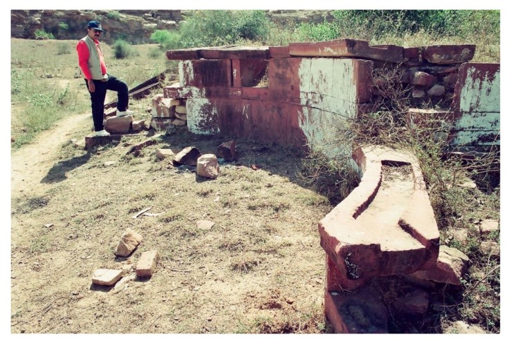
In the area between the southern wall of the daftarkhana and Shah Quli’s bāoli a number of piers which once carried water ducts still survive. Similar aqua ducts appear to have been constructed to the east of the storage well. During the course of the survey, bases of two such piers were encountered.

The water thus supplied from the northern and southern water works to the Imperial complex was distributed to various sections through the conducts running between the wells. Unfortunately, we encounter a number of gaps in these channels running through~ the Imperial complex. This probably is due to the renovation work which was undertaken under Lords Mayo and Curzon.

A physical survey of Fathpur Sikri reveals that still enough evidence survives to connect the various palace complexes. The major supply to the Imperial complex was through the Northern water works, whereas the Southern water works catered mostly to the needs of the civic population a function which it still performs.

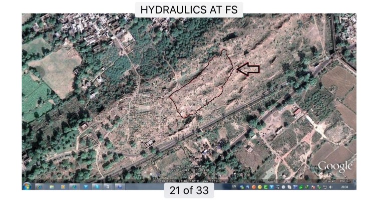
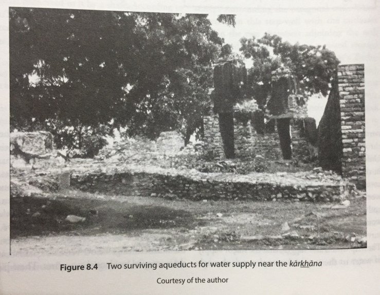
Apart from the bāolis, wells and tanks, a number of piers of the aqua ducts survive around the city of Fathpur which give us same idea of how water was carried from one area to another. For example a series of such piers survive in the area below hauz-i shirin, on the slopes of the northern ridge, below the so-called Tansens’ Bāradari and the excavated residential structures. These piers carried the aqueducts which connected the Northern works with the large water tank situated near the nobles, houses, mentioned earlier. This massive tank is 28.10 m. wide and 67.40 m long. Probably the entire needs of the Eastern area were met through the water stored in this tank.

It is also important to note that the individual residential structures, which have been excavated at Fathpur Sikri in most cases, seem to have had their own water storage tanks.

There are still areas in Fathpur Sikri, for example the areas in the South-west about which not much is known. A number of wells survive in that region, but they appear to be insufficient to cater to the entire needs of the population who must have settled there, The water must have been carried from here to individual houses through water carriers.

• Syed Ali Nadeem Rezavi

Water Tanks at Fathpur Sikri

Apart from the major tanks in the palace complex, around six rectangular and one square tank (hauz) – to store water were also located during the course of the survey.

Of these, five were found in the so-called Indāra Valley, near the Ajmeri Darwaza, an area reserved for pleasure resorts and gardens. The sixth water tank is located in the residential area reserved for the nobility on the north-eastern spurs of the ridge. This tank, which has recently been discovered, is situated between the nobles’ quarters and the rows of excavated shops of the Bāzār-i buzurg-i Sangin (the large stone market).

This was a very large water tank to meet the needs of the noble’s houses, the market, as well as the sarāi located near the Agra Gate.

A square water tank is situated atop the ridge on the extreme west, at a distance mid-way between the old Chishti quarters and the Chor Khirki. A modern cremation

ground is situated adjacent to this tank.

This tank in many of its features resembles the Anūptalāu situated in the Daulatkhāna. Constructed of rubble stone, each side of this tank is provided with steps. In the centre is a square platform which is connected with a cause-way on all the four sides. It is interesting to note that all around this tank are the ruins of structures, which unfortunately have yet to be studied. The area also yielded a large number of low and medium quality blue ware sherds.

Water harvesting appears to have been the major objective of the tanks situated on the top of the ridge. The major source of water for these tanks was the rain water which

was harnessed into them through slopes and channels. We have the testimony of Abul Fazl that rain-water mixed with Ganges water was used to prepare food in the Royal

Kitchen. A survey of the existing water channels confirms this statement. The tank situated near the matbakh (Royal Kitchen) and the office (yātishkhāna) of Muhammad Baqir Sufrachi, the superintendent of the Kitchen establishment was, and still is, filled by the rainwater falling on the courtyard of the Daulatkhāna. Constructed on the tapering spurs of the ridge, this tank, popularly known as the ‘Hauz-i-Shīrīn‘ (the Sweet Water

Tank), is raised on vaults.

Similar harvesting of rain-water appears to have been resorted to in the Jāmi’ Masjid Complex. The water “falling on the floor of the Mosque as well as the Tomb of Shaikh Salim Chishti was collected in two underground covered water-tanks (birka) one of which was constructed by the walling up of the vaults forming the courtyard of this

mosque. The other was situated beneath the langarkhāna to the south-east of the Buland Darwaza. Both were supplied through a labyrinth of underground channels collecting rain water falling on the structures situated within the mosque. Water from the ceiling of the mosque and the Tomb of Salim Chishti was also directed through similar drains constructed below the ground to the octagonal bāoli and tank (jhālra) situated to the west of the Buland Darwaza.

The tanks situated in the plain (e.g. the Indārā Valley) were, on the other hand filled by drawing water from the wells situated nearby. The survey revealed some of the water-channels connecting the tanks with their wells.

Architecture under Aurangzeb: A Note

There is a general belief that as with other court sponsored cultural arts, during Aurangzeb’s reign there was a sudden decline in architecture as well. As he was a staunch Sunni, he is said to have not only commissioned only religious buildings like mosques, he was also responsible for the destruction of many of the temples.

A look at modern works and explorations however reveal that Aurangzeb also commissioned structures like sarais, baths, gardens, tombs and fortified walls. Is this not true for other reigns as well? He is also credited to have repaired mosques built during earlier reigns and built many within captured forts.

The best known mosques of Aurangzeb’s period include the Moti Masjid in the Delhi Fort, a mosque on the site of the Keshav Dev Temple at Mathura (destroyed 1669-70) and the Badshahi Mosque of Lahore.

Mathura Mosque

Badshahi Mosque, Lahore

The first and the last are very ornate structures: the Moti Masjid is a marble structure, while the Lahore mosque is a red sand stone structure with insertions of white marble. The Mathura Mosque is more austere and resembles the mosques built by royal ladies of Shahjahan’s reign.

Some of the architectural features which distinguish the mosques constructed during the reign of Aurangzeb are as follows:

1. Most of these mosques stress their vertical elevation: they are all provided with minarets which provide them with the vertical perspective. This is true not only for the above mentioned mosques, but also for the Jami’ Masjids at Mathura, Merta and Varanasi.

2. As pointed out by Ebba Koch, the ornamentation is richly organic, which not only reflects Aurangzeb’s lack of personal interest, but also that forms once appropriate for the palace architecture, such as the ornament on Shahjahan’s Delhi throne, were now utilized on palace mosques.

Tombs

As far as the Tomb architecture under Aurangzeb is concerned, it is best represented by the Tomb of Rabia Daurani (who died in 1657) built in 1660-61.

Although a rough copy of the Taj, it reflects a new aesthetic that developed in Aurangzeb’s reign. Just as in the case of mosques, instead of perfect balance of proportions which were a hall-mark feature of Shahjahan’s reign, there is an emphasis on verticality. Further, though generally discussed as evidence of ‘decline’, this tomb reveals a new spatial arrangement, as well as a highly naturalistic fine floral ornament, much of it in stucco, which according to Catherine Asher, renders it as quite innovative.

With this tomb also truly ends the long established imperial tradition of setting monumental mausolea within a chaharbagh: Now we find burials within courtyards of mosques or shrines with just a screen and a cenotaph – the grave of Jahanara, the tomb of Aurangzeb at Khuldabad.

Grave of Jahanara, Dargah Nizamuddin

Was this just a full circle: from an open to sky tomb of Babur at Kabul to Aurangzeb’s tomb at Khuldabad? Probably where the resemblance ends is that the former is located within a garden, the latter within a Chishti shrine

Marble Screen around the grave of Aurangzeb

The simple open grave of Aurangzeb

Wells and Step-wells at Fathpur Sikri

The demand for potable and irrigation water at Fathpur Sikri, apart from the lake, was also taken care of by digging a large number of wells (chāh) and constructing a number of bāolis (step-wells) scattered all over the town.

We have evidence that among Babur’s constructions at Fathpur Sikri there were at least two step-wells and a well.

Dealing with the renunciation of wine during his campaign against Rana Sanga, Babur writes (in AH.933/Feb-, 1527):

At the place where the wine was poured upon the ground, a well was ordered to be dug, built-up with stone and having an almshouse beside it. It was already finished in Muharram 935 (Sept. 1528) at the time I went to Sikri from Dho1pur on my way back from visiting Gualiar.

An inscription of the same year (933 / 1526-27) was discovered during the 19th century, adorning the well of a step-well known as Indārāwāli bāoli. The inscription

recorded that:

At the command of Zahiruddin Muhammad Babur, Badshahi Ghazi (May Allah perpetuate his realm and rule) the construction of this well was, through the divine grace, completed in the year 933 A.H. after (the Emperor) had returned conquering and victorious from his campaigns against the misbelieving Rana Sanga.

Babur’s Baoli in Indāra Ghāti

The information contained in the Bāburnāma and the location of the inscription suggests that the so-called Indārāwāli bāoli was constructed some time in 1527 on the orders of Babur. Architecturally, the bāoli resembles the well of the Bāgh-i Nīlofar constructed at Dholpur upon orders issued the same year.

At both the wells, a wide chhajja like octagonal ledge replaces the coping, which is supported by carved “Hindu” brackets. A deep flight of steps, leads to the octagonal well. Interestingly there are 13 steps up till the first platform, then 12 and ultimately 11 which descend to the water level. There are pillared galleries (dālān) at each level of the shaft which are adorned with rosettes, carved brackets and ‘chandrashālās’ (niche-like forms) on the pillar bases which are typical features of Babur’s time.

The well is octagonal and was once provided with pulleys. At the exterior, four sides of the octagon are curved into circular tanks. A rectangular tank to collect water is also provided for at the back of the octagonal well. Aligned to the North-East of this bāoli are the remains of the Chahārbāgh. Although the site is now a cultivated field, the contours of the garden are still discernible. A bāoli or well could never have stood in isolation. Probably this

garden of the Indārāwāli bāoli was also constructed alongside with the step-well, and was thus a Baburi Garden.

Towards the west the remains of another bāoli are traceable, the stones (khanda in the local usage) of which having been shorn away by the present owners who use this area as a tilling field.

While interviewing a number of senior residents of Sikri, Nagar and Fathpur during the course of my survey in the first week of March 1996, my informants spoke of the existence of as many as 52 bāolis and 108 masonry wells till the fourth decade of the present century. The survey of the area however revealed 14 stepwells and over 60 wells, all of the period when Fathpur Sikri was built.

Among the stepwells or bāolis which were located during the course of the survey, some were in a very dilapidated condition. Since these may soon disappear, it is worth recording them here:

(1) Octagonal bāoli below the Hathipol;

(2) Indarawali bāoli in the Indara valley;

(3) Shahjahani bāoli in the garden to the west of Hathipol Sarai;

(4)bāoli to the west of Babur’s Bagh-i Fath (only traces remain);

(5) bāoli near the so-called ‘Matiya Mahal’, near the Qush Khana (only outlines visible) ;

(6) the four-storeyed grand bāoli around 300 metres outside Ajmeri Darwaza;

(7) Moti Bagh bāoli, now in the main bāzār of Fathpur, adjacent to the northern Gate of the four-laned Akbari bāzār, popularly known as ‘Pukhta Sarai’;

(8) bāoli in Muhalla Katra, near Purana Dakhhana;

(9) Shah Quli’s bāoli near the so-called ‘Hakim’Baths’ (the Imperial Baths);

(10) bāoli near the Gwalior Darwaza, adjoining chahārbāgh;

(11) bāoli around 300 metres outside AgraDarwaza, on the Agra road, (besides the modern wine-shop) ;

(12) bāoli to the east of the Agra-Bharatpur road, outside the Lal Darwaza;

(13) bāoli to the north of the Bharatpur-Agra road towards Nagar;

(14) bāoli to the north-west of the Buland Darwaza popularly known as the jhālra.

As can be seen from the appended plan depicting the placement of the sources of the water-supply, these step-wells were fairly evenly located all around the medieval settlement of Fathpur Sikri. The survey further revealed that nearly all these bāolisexcept nos. 4 and 5) still contain water, and need only minor repairs to make them functional.

Out of these 14 bāolis which could be located so-far by the author, eleven belong to Akbar’s period; one (no.12) pre-dates the Mughals, to judge from the carving of

the stone, probably a remnant of the Sikriwal Rajput rulers. Another belongs to Babur (No.2). Bāoli No.3 was constructed during the reign of Shahjahan. Five of them (Nos. 1, 2, 7, 9, &14) have octagonal wells, while the rest are square. Apart from being a regular source of potable water, these step-wells also acted as pleasure-resorts where the weary travellers could rest.

• Syed Ali Nadeem Rezavi

Golābi: The Lake of Fathpur Sikri

The remains of Fathpur Sikri situated as it is on a ridge supply us some vital clues to the techniques of Water-management and hydraulics. As a rule the pre-modern

settlements generally grow around some major source of water, such as a river, a lake or a pond, which would not only act as a source of potable water, but also provide a barrier for security. It is also generally observed that within a settlement, the areas closer to the source of water was reserved for the more influential sections of society. This may be seen at Delhi, Agra, Ahmadabad and Cambay. It is in this light that we may study the lay-out and water-supply system at Fathpur Sikri.

Before the founding of Fathpur as a capital city, the village of Sikri was a “well-watered” ground which could sustain a large army. Babur testifies to the abundance of water at Sikri (on the plain by the side of the lake) when he mentions the ‘kol’ lake near this village. When in 1571-72 AD orders were issued by Akbar to construct the city of

Fathpur, the major elements of the town were planned not around this lake, but on the broad top of the too ridge and on the plain towards the south of the ridge. The scheme of

placing the important structures and influential sections along the banks of the water reservoir was not followed at Fathpur Sikri.

Abul Fazl specifically mentions that the lake (golabi) was situated ‘below the town’ (piwast-i shahr) on whose banks ‘His Majesty constructed a spacious courtyard (saffa), a minār and a chaughāngāh (polo-ground), where elephant fights are organized’.

Our sources however reveal that the lake of Fathpur Sikri remained the major source of water-supply to the city. To quote Fr.Monserrate who visited the city in 1580-81 with the first Jesuit Mission:

To supply the city with water a tank has been carefully and laboriously constructed two miles long and half a mile wide. The work was performed, by the King’s direction…

A survey of the dry bed of the lake of Sikri reveals that though it is formed by a natural depression of the ground between the Sikri ridge on the south and certain spurs in

the north-west near the village of Rasulpur, it was regulated by the construction of two barrages, viz., the Terah Mori and the Bāwan Mori. The Terah Mori barrage, situated exactly to the north of the lake, on the Agra-Bharatpur road comprises thirteen arches which contained wooden sluices to release the excess water.

To the north-east of it is constructed the more heavily built barrage now popularly known as the Bawan Mori, which as the name suggests once comprised fifty two sluices. This earthen barrage forms the limit of the lake towards the old township of Nagar. The excess water released from these barrages flowed into a rivulet which then passed on towards the east, crossing the Agra-Sikri road near the town of Kirauli.

This rivulet provided water to the area situated to the east of Fathpur Sikri. The lake was fed through two sources, a channel drawing in the Utangan River, now known as Khari Nadi, and rain water. It appears that these barrages and dams which regulated the natural lake were constructed by Akbar in 1579 AD. In a letter to Fr. Peres written in 1580 AD, Fr. Henrique, a member of the Jesuit Mission reported:

…about a year ago, in order to improve the city, water has been led in from somewhere to form a sizeable lake which is perennial. All the elephants, horses and cattle drink from it, and it also serves the teeming population for all purposes.

Fr. Monserrate is however, much more explicit:

Across to the end of a low-lying valley which was filled with water in the rains,(although the water afterwards drained away or dried up), a great dam was slowly built. By this means not only was a copious supply of water assured, but the discomfort of the climate was mitigated.

It is interesting to note that our sources vary when they discuss the size of this lake, though all agree that it was very large.

Fr. Monserrate, in 1580, as we have seen, mentions it to be ‘two miles long and half a mile wide’. In 1610, when William Finch visited Fathpur Sikri, he found it “2 or 3 cos in length”.

Nine years later, in 1619 when Jahangir ordered it to be measured, and found its circumference to be 7 koss. Later in 1633, Peter Mundy reported it to be “10 or 12 mile long”. Though these statements vary, they can partly be explained by the seasonal changes in the volume of water and partly by the vulnerability of the subjective estimation. But it is clear that at least until early in Shahjahan’s time the lake had maintained its extremely large size.

• Syed Ali Nadeem Rezavi

Design and Building Techniques of Babri Masjid, Ayodhya

This is my note [Note 1.3] in the Aligarh Historian’s Society [AHS] report to the nation entitled “HISTORY AND THE JUDGEMENT OF THE ALLAHABAD HIGH COURT, LUCKNOW BENCH, IN THE RAMJANMABHUMI–BABRI MASJID CASE” circulated after the High Court Judgement of the Lucknow Bench of Allahabad High Court came in 2010

The basic plan of the Babri Masjid is reminiscent of the Tughluq, Lodi and Sharqi architectural traditions. It consists of a western liwan (prayer chamber) divided into aisles and a central nave. All the three are single-bayed, fronted with arched openings and covered with domes. The nave is comparatively larger than the flanking aisles. To the east is a small courtyard, which at some later stage was further enlarged with the placement of an outer screen and a gateway.

The whole structure, as was common in the Tughluq and Lodi periods was built of rubble stone masonry overlaid with a thick veneer of lime plaster. As visible from a photograph of the western wall of the mosque, rubble stones alternated with layers of calcrete and sand stone blocks.

Similar type of construction is witnessed in other 13th to 15th Century structures located in and near Ayodhya. An example can be given of the two very large ‘graves’ of the ‘prophets’ – one near the palace of the Raja of Ayodhya, and the other at the old cemetery on the outskirts of Ayodhya, and the medieval monuments around them.

The nave of the western liwan is fronted with a high propylon, reminiscent of the architecture of the Sharqi period.

The propylon is provided with a trabeated opening covered with a drooping eave resting on heavy stone brackets. The sides of the pylon are decorated with heavy stone projected balconies and a series of niches in the form of arch-and-panel articulation with floral medallions embossed within.

The arches employed throughout the structure are pointed arches which were generally preferred during the period before the establishment of the Mughal mode of architecture under Akbar. The

Mughals, from the period of Akbar onwards, preferred the four-centred Iranian arch, which due to its profuse use came to be known as the ‘Mughal Arch’.

The domes of the Babri Masjid were typical ‘Lodi Style’ domes, raised with the help of stalactite pendentives (as against squinches), resting on octagonal heavy necks and topped with inverted lotus crestings. The domes of Babri Masjid at Ayodhya were similar to the domes of the ‘Moth ki Masjid’ in Delhi, constructed during the reign of Sikandar Lodi (1498-1517) by his prime minister

Miyan Bhuwa.

From the period of Akbar onwards, the style of mosque architecture drastically changed: Now the preferred style was the mosque having a centrally located courtyard surrounded on all sides by the riwāqs (cloisters) and the liwan. The cusped arches, baluster columns and other intricate decorative features were also added.

By Shahjahan’s time a further innovation took place – the minaret started emerging as a part of the mosque complex and by the period of Aurangzeb it became almost an essential feature.

The mosques built under Aurangzeb and later Mughals were totally of a different kind as compared to the plan and elevation of the Babri Masjid. Almost all of them incorporate architectural features developed and used by the architects of Shahjahan. Thus nearly all of them have bulbous domes ( a fair number of which were ribbed and of marble) resting on constricted necks; the preferred arch type was that of the multifoliated cusped arches and tall domineering two or four minarets – almost all the mosques from this period onwards had the minarets as an essential architectural feature.

Examples can be given of such imperial mosques as the Badshahi Mosque at Lahore, the Jami’ Masjid and the Idgah Mosques of Mathura, the Gyanvapi and the Jami Mosque of Varanasi, as well as the Jami’ Masjid of Muhammad Shah at Aligarh.

Professor Syed Ali Nadeem Rezavi

Note: I had visited the site a number of times when the Court sponsored Excavations were taking place, having been appointed as an “Observer” by the Honourable Court.