Syed Ali Nadeem Rezavi
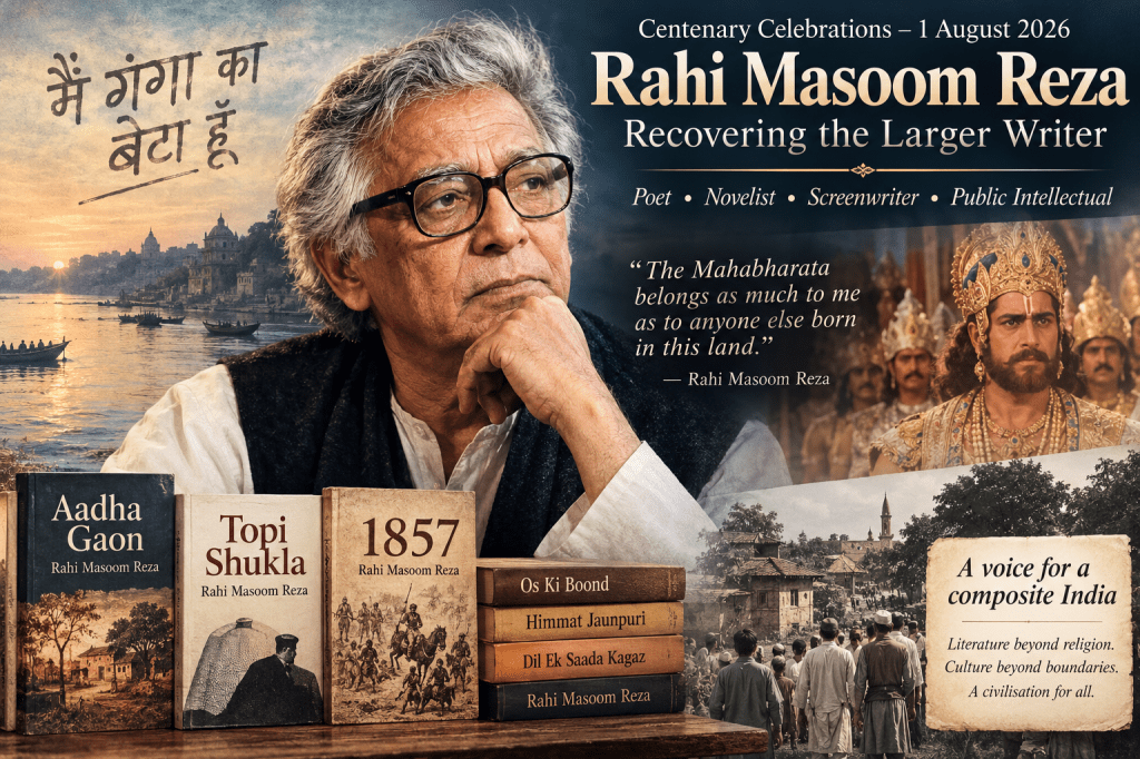
On 1 August 2026, as we commemorate the birth centenary of Professor Rahi Masoom Reza (1926–1992), there is a curious irony that deserves reflection. The man who spent his entire life resisting labels has himself become imprisoned within a single cultural memory. For millions of Indians, Rahi survives chiefly as the writer of the television serial Mahabharat (1988–90), whose unforgettable opening invocation of Samay – “Time” – became etched into the consciousness of an entire generation:
“मैं समय हूँ…” I am Time…
Rahi Masoom Reza’s opening invocation presented Time (Samay) as the eternal witness to all of human history. It was sutradhar through whose eyes we view our past to understand what we are. Samay declared that it had seen empires rise and fall, kings and warriors come and go, and countless generations repeat the same struggles between justice and ambition, truth and falsehood. The Mahabharata, it was thus suggestsed was not merely the story of one ancient family but the story of humanity itself, for the conflicts of greed, power, duty, love and sacrifice recur in every age. The narration invited the viewer to see the epic not as distant mythology but as a timeless mirror in which every generation can recognise its own moral dilemmas.
For nearly two years, every Sunday morning at 9.30, India appeared to suspend itself. Streets fell silent. Public transport ran half empty. Shops opened late. Families, neighbours and friends gathered around television sets in villages and cities alike. Religious identity momentarily dissolved before a shared narrative that belonged to everyone. It is difficult today to explain to younger generations the extraordinary cultural phenomenon that Mahabharat became. There had been successful television serials before it, but none that united India in quite the same manner. That a Muslim scholar from Ghazipur should become the voice through which much of modern India rediscovered the Mahabharata remains one of the finest illustrations of India’s composite civilisation. For countless Indian Muslims too, the serial offered their first sustained encounter with one of the foundational epics of the subcontinent. It reminded them that the Mahabharata, like the Ramayana, was not the property of any single community. It belonged to the civilisational inheritance of everyone who called India home.
Yet therein lies the tragedy of memory. The overwhelming success of Mahabharat has obscured the larger literary personality of Rahi Masoom Reza. He deserves to be remembered not merely as the scriptwriter of an immensely popular television serial but as one of the most original Urdu poets of the twentieth century, an important Hindi novelist, a fearless public intellectual, a distinguished academic and among the finest dialogue writers Indian cinema has ever produced.
Rahi Masoom Reza was born on 1 August 1926 in Gangauli, a village in Ghazipur district of eastern Uttar Pradesh. The landscape of Purvanchal, with its mingling of Hindu and Muslim traditions, its dialects, festivals, shared memories and everyday coexistence, never left him. Even after migrating to Bombay and achieving fame in cinema, the soil of eastern Uttar Pradesh continued to nourish his imagination. His village became not merely a geographical location but a metaphor for India itself.
His education at Aligarh Muslim University shaped him profoundly. At Aligarh he completed his higher studies in Urdu and eventually earned his doctorate. He later joined the Department of Urdu as a lecturer. The intellectual atmosphere of Aligarh in the years immediately following Independence exposed him simultaneously to classical Persian and Urdu literature, modern literary criticism, Marxist thought, progressive literature and the complex debates surrounding nationalism, language and identity.
Although later generations often remember him as a novelist, Rahi first established himself as a poet. He published seven collections of Urdu poetry and was recognised by critics as one of the most distinctive poetic voices to emerge after Independence. His verse combined lyricism with political consciousness, tenderness with irony, and personal experience with historical reflection. Unlike poets who remained imprisoned within inherited conventions, Rahi continually experimented with language while retaining an unmistakably Indian sensibility. Among his poetic achievements, his long poem 1857 occupies a unique place. Rather than presenting the uprising merely as military history or nationalist mythology, he transformed it into a meditation upon memory, loss, betrayal and the making of modern India. The poem mourns not simply a defeated rebellion but the fragmentation of a civilisation whose composite culture had once flourished across north India. It remains one of the significant long poems in modern Urdu literature and alone would have secured him an honoured place in the Urdu canon.
Yet poetry was only one aspect of his creativity. His novels fundamentally altered modern Hindi fiction. The irony itself is striking. An Urdu scholar by training chose Hindi as the principal language of his novels, demonstrating that the division between Hindi and Urdu was largely political rather than cultural. His masterpiece, Aadha Gaon (Half a Village), published in 1966, remains one of the greatest novels produced in post-Independence India. Set in Gangauli during the final years of British rule and the trauma of Partition, it refuses simplistic narratives of communal conflict. Instead, it portrays a society whose shared relationships are slowly eroded by political developments imposed from outside. The novel captures the rhythms of rural life with extraordinary authenticity while exposing the tragic absurdity of identities that become hardened under the pressures of modern politics. Its language itself was revolutionary. Rahi allowed the speech of ordinary villagers to enter literature without apology. Bhojpuri, Awadhi, Urdu, Persian expressions and colloquial Hindi coexist naturally, reproducing the multilingual reality of north India rather than the artificial purity demanded by language ideologues.
His subsequent novels, including Topi Shukla, Os Ki Boond, Himmat Jaunpuri, Dil Ek Saada Kagaz and others, repeatedly explored questions of identity, belonging and secularism. In Topi Shukla, perhaps his most explicitly political novel, friendship becomes the prism through which the hypocrisies of post-Partition India are examined. It remains one of the sharpest literary critiques of communalism written in modern Indian literature. Throughout his writings, Rahi refused to accept that religious identity determined cultural identity. This conviction became the defining principle of his intellectual life.
Perhaps no episode illustrates this better than the controversy surrounding his authorship of Mahabharat. Some objected that a Muslim had been entrusted with writing dialogues for what they regarded as a sacred Hindu text. Rahi’s response has since become legendary. He reminded his critics that he was neither an Arab nor a Turk. He was an Indian. The Mahabharata belonged as much to him as to anyone else born in this land. It was part of his inheritance. That simple assertion represented something much larger than personal defence. It articulated an understanding of India rooted not in religious exclusivism but in shared civilisation. It rejected the notion that literature, history or culture could be partitioned according to faith.
His adaptation of the epic reflected precisely this understanding. Rather than reducing the Mahabharata to theological instruction, he presented it as an exploration of moral ambiguity, political power, human frailty and ethical responsibility. The dialogues retained a literary dignity while remaining accessible to millions of viewers. Characters were rendered psychologically complex rather than merely symbolic. The serial succeeded not because it preached religion but because it revealed humanity. His famous opening narration on Time itself possesses remarkable philosophical depth. Time appears not merely as chronology but as the ultimate witness before whom kings, empires, victories and defeats all pass away. In many respects, that meditation reflects the historical imagination of a novelist rather than the outlook of a television scriptwriter.
Bombay brought Rahi another arena in which to display his astonishing versatility. He wrote dialogues, screenplays and lyrics for numerous films over several decades. His association with filmmakers such as Gulzar, Hrishikesh Mukherjee, B. R. Chopra and others produced dialogues that combined literary elegance with everyday speech. Unlike many writers who regarded cinema as a compromise, Rahi treated popular culture with seriousness. He understood that films could communicate ideas to audiences vastly larger than literary journals ever could. Even while working within commercial cinema, he retained his unmistakable voice. His characters spoke like real people rather than literary abstractions. Humour, irony and emotional restraint characterised much of his writing. He possessed an extraordinary ear for spoken language.
Yet behind the celebrated public figure stood a deeply committed secular intellectual. Rahi consistently opposed every attempt to divide Indian society along communal lines. He criticised both Hindu and Muslim communalism with equal courage. He believed that India’s strength lay precisely in its shared cultural traditions and its capacity to absorb multiple histories into a common civilisation. His lifelong attachment to the Ganga became almost symbolic. He often described himself not in terms of religion but in relation to the river and the landscape that had shaped him. The Ganga represented continuity, memory and belonging beyond sectarian identities. In one of his most moving reflections, he wrote that if anyone asked who he was, the answer was simple: he was a son of the Ganga.
This profound attachment to place also explains why nostalgia never became sentimental in his writings. He mourned the disappearance of an older India not because he rejected modernity but because he feared the destruction of its composite social fabric. He recognised that villages were changing, languages were becoming standardised and identities increasingly politicised. Much of his fiction is therefore an attempt to preserve voices, memories and relationships before they disappeared.
As a teacher at Aligarh Muslim University, Rahi inspired students not merely through scholarship but through intellectual independence. He belonged to that generation of academics for whom literature was inseparable from public responsibility. Writers were expected not simply to entertain but to intervene in the moral life of society.
Today, more than three decades after his death, his concerns appear remarkably contemporary. Questions of identity, language, history and belonging continue to dominate public discourse. Attempts to claim exclusive ownership over India’s past have become increasingly frequent. In such a climate, Rahi Masoom Reza’s life offers an alternative vision of patriotism, one grounded not in exclusion but in cultural confidence. Remembering him only as the writer of Mahabharat therefore does him an injustice, even though that achievement remains monumental. He was far more than the creator of memorable television dialogues. He was among the finest Urdu poets of his generation. He transformed the Hindi novel through works of enduring significance. He enriched Indian cinema with language of rare literary quality. Above all, he embodied the composite civilisation that he celebrated throughout his life.
This remembrance is also personal to me. I was fortunate enough to meet him on a number of occasions with my father – a man of religion, to boot – and those encounters left an indelible impression upon a young mind. I remember the warmth of his presence, the quiet wit that sparkled in his conversation, and the complete absence of any pretension despite his towering achievements. He made you feel that literature was not a distant pursuit but a living, breathing engagement with the world. The Rahi I met was not the celebrated public figure alone but a man of deep affection, keen observation and an abiding faith in the essential goodness of ordinary people. He belonged to that rare breed of writers whose life and work were seamless.
It would also be remiss not to recall his elder brother, Moonis Raza (d.1994), who shared the same intellectual soil and was an eminent Indian academic administrator, geographer, and a founder-chairman of the Jawaharlal Nehru University (JNU). The third brother was Prof Mehdi Raza, (d.2015) who was the head and professor of geography at Aligarh. The Raza family of Gangauli produced not one but three sons of extraordinary calibre, each in his own way contributing to the nation’s life. The brothers remained close, and one can only wonder at the conversations that must have passed between the novelist who chronicled India’s soul, the geographer and the diplomat who represented India’s face to the world. Their shared inheritance – the same village, the same river, the same composite culture – nourished two distinct but equally remarkable careers.
On his centenary, the greatest tribute we can offer Professor Rahi Masoom Reza is to recover the whole writer. The poet who mourned the wounds of history. The novelist who chronicled the disintegration of rural India. The scholar who crossed linguistic frontiers with effortless ease. The screenwriter who brought an ancient epic alive for modern audiences. And the Indian who insisted that culture cannot be divided by religion because civilisation is always larger than faith. His Mahabharat gave India unforgettable words. He did to Mahabharata what Tulsi had done to Ramayana: brought it to the masses. His larger body of work gave India something even more precious: a language through which it could recognise itself. As we honour his memory, let us remember that the voice which once invoked Time itself now belongs to eternity – and yet, in his pages, he remains forever our contemporary, speaking to us across the decades with undiminished urgency and love.