
Tughluqabad is conventionally the (Indarpath? Qila Rai Pithora, Siri) fourth city of Delhi. Built between 1320 and 1325 AD by Ghiyasuddin Tughluq, it was abandoned within a generation. According to Zia Barani, its construction started soon after Ghiyasuddin Tughluq’s accession. According to Ibn Battuta, its site was in the mind of the Sultan even when he was a minister in the court of Mubarak Shah. The architect was Ahmad bin Ayaz, an Anatolian (Rumi) malikzada.
It was built over a period of around 2 years and it was declared the dar us sultanate in 1322-23. In 1352 Ghiyasuddin died and was succeeded by Muhammad Tughluq who soon after ordered the construction of Adilabad, which was a new citadel. Tughluqabad and Adilabad are connected with each other by a causeway, which was also a dam to hold the lake water. Soon after was founded the new city of Jahanpanah. Thus Tughluqabad ceased to be the capital. A severe draught in North India and the transfer of capital to Daulatabad appears to have caused a total collapse. Firuzshah (1351-88) during his reign shifted to his new city of Firuzabad, far north of Tughluqabad. This led to a total desertion of the Tughluqabad site.
Thus like Fathpur Sikri, Tughluqabad is a fossilized town having buildings dating back to a brief period and a single reign.
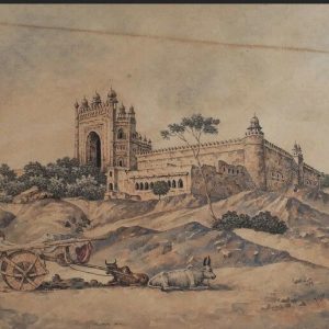
For the brief period that it did exist, it was a splendid city, the magnificence of which is attested to by Ibn Battuta:
“Tughluq’s treasury and palaces are located there, and in it is the greatest palace, covered with golden brick, which, when the sun shines, reflects dazzling light, preventing the eyes from looking at it for long…”
This probably was a reference to the lustre painted ceramic tiles, which were extensively used in Iran during the 13th and 14th Century.
The site of this town, spread over some 300 acres, is located on a hill surrounded by a low lying area ( a basin) where water collected during the rainy season. This seasonal lake was regulated by the construction of a number of dams. The result was that a lake was created to the south of the city which supplied water to the town as well as irrigated the fields all around.
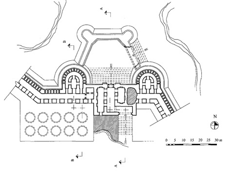
The plan of the city of Tughluqabad appears to have been inspired from Khurasanian (or Iranian) models represented by such towns as Bust, Nishapur and Tus: It comprises of three distinct areas – (a) the lower town (pā‘īn shahr); (b) the upper town (bālā hisār); and (c) the citadel (arg). Generally the Iranian towns conspired of two enclaves, the main town (shahristān) and the citadel.


The main town of Tughluqabad appears to have been larger than Siri: its ramparts enclose an area of around 6 Km. The main streets were almost 2 Km long. These ramparts do not appear to follow any geometrical pattern or form, but follow the natural contours of the hill on which the city is located. The general layout of the city is in the form of a trapezium, i.e., a quadrilateral with only one pair of sides parallel. Its massive walls are made of rubble and sand mortar and cased with dressed stones quarried locally. The casing stones are large blocks of stones measuring generally 0.5 × 0.5 × 2 m. Some are bigger and some even as large as 3m.
The thickness of these walls differs: the maximum is 10m. The height reaches up till 30m, but on an average, it varies between 10 to 15m. These walls are pierced with round towers at regular intervals and 12 gates on the outside, while 2 gates are situated between the fort and the town. A single gate connects the fort with the citadel.
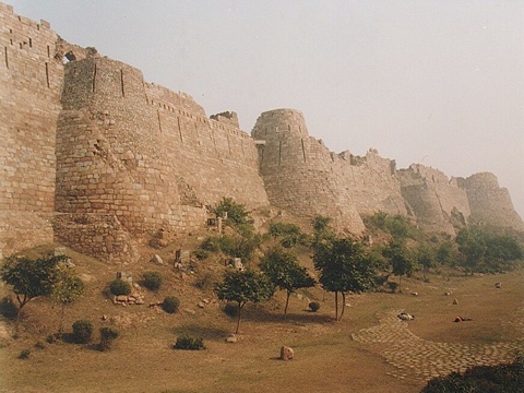
Typical of the period, the ramparts, the bastions and the gates are all tapering (i.e. cyclopean / battered) in form.
The citadel is situated to the south of the town, on the highest point of the hill. It comprised private imperial structures, and thus it is here that we find a three-tiered defence system: (a) a sharply battered first tier with a 2m wide ledge protected with battlements (parapet with indentations), loopholes (slits in walls for firing guns), and merlons (crenellations, or solid wall between two openings); (b) a second wall 5 – 10 m high with a barrel-vaulted gallery; and then (c) on top of this arch-shaped battlements with loopholes.
The most prominent structure in the citadel appears to be a pavilion (no.5), the Jahan numa, which possibly was Ibn Battuta’s ‘great palace of golden brick’.
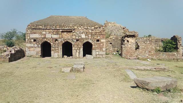
Most of the buildings and palaces in the citadel have disappeared and what remains is only the under ground cells which made up the plinth / platform on which these structures were situated. The only surviving building in the area is a small mosque (no.8).
The fort is situated to the south-west of the town. On its south is the lake. The other exposed sides are defended by a moat.
This fort consists of four main gates and two postern gates. A gate from the north leads from this fort to a straight street known as Khās Bazar ending at the Dhoban Dhobani Gate. The East Gate opened on a short processional street leading to the Jami’ Masjid.
Behind the East Gate was the Royal Square (maidan) [no.9] measuring 180 × 120 m to the south and west of which are the ruins of various buildings, probably public buildings including audience halls, stables etc.
The Street Layout:
Inside the town, most of the street layout is still preserved. There appears to be a well defined grid-plan for the roads which run from gate to gate. The main streets are fairly straight and some of them are aligned with north-south or east-west coordinates.
Three of these streets, which end at the gates, may be called the main streets: two of these commence at the north-east corner of the fort, one leading north and the other east.
The road between the East Gate of the fort and the gate in the centre of the Eastern side (Rawul Gate) although short, appears to be the main ceremonial and bureaucratic passage. Probably just outside the East Gate of the fort, there was a chauk (square) as the Iranian tradition also followed in many Sultanate towns like Nagaur, Bidar and Ahmadabad. And probably as in those places, it was surrounded with buildings and shops, but nothing survives. Probably it was a square for common people and a place for civic and commercial activity. According to Mehrdad and Natalie Shokoohi, an old aerial photograph hints of traces of buildings surrounding this area.
Another road from the north of this square led to the end of the town. This street was parallel to the one of Khas Bazar, and it was along this that two market squares are located in the middle of the town.
These two principal roads are linked with at least 3 streets. A street also ran along the fortifications and was probably meant for access to the walls and their defence.
Residential & Commercial Areas:
The house structures and other buildings were generally oriented along the streets. Probably the residential areas of the town were towards the north and the houses were planned around one or several courtyards. The residential areas were compactly built with narrow side-streets giving access to the main streets. Some residential structures also probably comprised private gardens. The residential areas also contained a number of small mosques for each quarter. There were some grander mosques as well.

As far as the commercial areas were concerned, we have noted at least two in the centre of the town. These are rectangular areas which probably were the whole sale grain markets (mandi). Shops and bazaars were also located along the main streets. The Khas Bazar appears to have been the main market street of the town with shops on either side. The ruins of shops have been found in the middle portion of this street. Such shops ran alongside the entire length of the road.
This street is about 20 m wide and at each side of it is situated a platform about 0.65 m high over which the shops were constructed in a row of equal sized units. Each of this shop was 3 m wide and 5 m deep. The platform fronting these shops was around 1 m wide. Although at Khas Bazar, only the lower parts of the shops survive, but it is enough to give the earliest example of how they were constructed.


An east-west street from the Khas Bazar area ran between Nimwala Gate in the north west and passed on to the Bazar squares in the centre of the town and the continued up to the Rawul Gate.
The Granaries:
Another remarkable feature encountered at Tughluqabad are the silos – the grain storage chambers – which have been found in large numbers built next to the walls both in the town and the fort. Ibn Battuta mentions anbārs of grain (granaries) in the cities of Delhi ‘some having edible grains from the time of Balban’.
These are massive but simple structures. One such set of silos is found near the Northern Gate: They are in the form of a large platform about 10m high having 10 circular domed chambers which are 6.50 m wide and 9 m deep. They are set 1 m apart from each other. The walls are solidly constructed with rubble stone and mortar. On one side of the flat domed roofs is a sloping chute by means of which the chamber could be filled and the filling would be monitored through a central hole in the dome. Once filled, both the chute and the hole could be closed and sealed.

Similar silos are found near other gates as well, for example the Hathi Gate, Rawal Gate, Bandoli Gate, and other places in the town and the fort.
A number of wells and reservoirs have also been located in and around Tughluqabad. There are two big baolis or step-wells, one in the Palace area and the other in the citadel. The main hydraulic works however are the sluice gates which regulated the lake. They have been initially surveyed by Tatsuro Yamamoto and his team.
Note:
The above writing is based on Mehrdad Shokoohy and Natalie H. Shokoohy, which they published in the form of three interim reports in the Bulletin of the School of Oriental and African Studies; Shokoohy and Natalie H. Shokoohy, Tughluqabad: A Paradigm for
Indo-Islamic Urban Planning and Its Architectural Components, London, 2007; and my paper on Bazārs and Markets in Medieval India published in Studies in Peoples History in 2015
• Syed Ali Nadeem Rezavi
