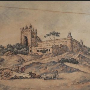

The area around the Qutb complex, known as Lalkot, is the earliest defense work in Delhi created by Anangpal II, who is also credited to have brought the Iron Pillar of Chandragupta II, which now stands in the Quwwat ul Islam.
The massive walls and bastions of the Lal Kot enclose the Qutb complex, the Anangtal and some other mounds. It is pierced by a number of gates.
According to Cunningham (I, p. 151), its date of construction is between 1052-60. He reaches this conclusion on the basis of the Mehrauli Iron Pillar Inscription:
“Samvat Dhilli / Dhihali 1109 Ang Pal Bahi”, i.e., “ In Samvat 1109 [1052 AD], Ang [Anang] Pāl peopled Dhilli”.
Buddha Rashmi Mani (1997), the archaeologist who took up some excavation work there and wrote a book on Delhi, read it as follows:
Samvat Kinllī 1109 Aṅgapāla bādi [Anangpal tightened the nail [iron pillar] in Samvat 1109]
Then we have two manuscripts, obtained from Garhwal and Kumaun regions which mention that Anangpal II built the fort in Samvat 1117 / AD 1060.
Perhaps taken together, one may gather that construction was started in 1052 AD, and completed in 1060 AD, eight years later.
The term Dhillika first appears in the Bijhli rock inscription found in district Udaipur, Rajasthan which was issued by the Chahamana (Chauhan) ruler Someshwar in VS 1226 / 1169-70 (Epigraphica Indica, XXVI, 1941-42, no. 9, pp. 84-112).

According to Meera Dass and R. Balasubramaniam (2004) the iron pillar was originally erected at Udayagiri in Madhya Pradesh. And as per the inscription cited above, it was relocated to Delhi by Anangpal. Later when the Turks built the city, it was either Aibek or Iltutmish who had it fixed within the congregation mosque.
The circumference of the ramparts is nearly 3.6 Km with varying thickness ranging between 3-9 m. The ramparts are surrounded with a ditch and the height of the ramparts is nearly 20m at some places. At intervals are semi-circular bastions.
Later on around 12th Century, Vigraharaja IV, the Chauhan (Chahamana) ruler of Sakambhari captured the Dhillika of the Tomaras. His grandson, Rai Pithora (Prithvi Raj III) extended this Lal Kot by throwing up massive ramparts around it. This enlarged city came to be known as Qila Rai Pithora, which was captured by Aibek in 1193.


In the 12th Century, the Tomar Rajputs were overthrown by the Chauhans of Ajmer who built the Qila-i Rai Pithora (Prithvi Raj III) with massive stone ramparts to defend it from the Turks. For this period, we have the bardic poem, Prithviraj Rāso composed by Chānd Bardai, which mentions that the fort here was in fact built by Prithviraj Chauhan [Prithviraj III].
Chand Bardai, is supposed to be Prithviraj’s court poet, who accompanied the king in all his battles. Chand Bardai, whose traditional occupation was to compose poems and ballads in praise of their patrons, based this ballad loosely on historical incidents. These balladeers were poets and scribes who accompanied the armies of their patrons and encouraged and exhorted the warriors to bravery in battle by reciting the great deeds of their illustrious clan forebears.
Over time, the Prithviraj Raso has been embellished with the interpolations and additions of many other authors. Only a small portion of the existing texts is likely to have been part of the original text. Several versions of the Prithivraj Raso are available, but scholars agree that a small 1300 stanza manuscript in Bikaner is closest to the original text. The longest available version is the Udaipur manuscript, which is an epic comprising of 16,306 stanzas. The language of the texts available today largely appears to be post-15th century.
The ramparts of this fort were pierced with 13gates, three of which open into the future city of Jahanpanah. The Badaun Gate towards the east is the most elaborate and well-known of these 13 gates. And if we believe Ibn Batuta, this was probably the main gate through which the city could be entered. And by the time Delhi was captured by Aibek, it already possessed 27 Hindu and Jain temples.
Dhillika under the Chauhans was but a provincial outpost. Excavations conducted in the area suggest that the Lal Kot was divided into two parts – the original western section, and a later eastern division. Y. D. Sharma, through his excavations brought to light structural remains of a Gate, ‘the Bhind Gate’ of the original Lal Kot.

Excavations have also proved that the extension of the Lal Kot towards the east was the area in which the Turkish Sultans and the Khaljis built their structures. Palaces like Kushak-i La’l (Ruby Palace) and the Kushak-i Sabz (Green Palace) were towards this side. J.D. Beglar had noticed large quantities of green enamelled tiles with Arabic inscriptions and ornaments, as well as corner and portions of a floor of a well plastered structure at the back of the Qubbat ul Islam Mosque. This tallies with the information given by Minhaj us Siraj, who tells us that the mosque stood outside the Lal Kot. Firishta also gives us the same type of information. While discussing the details of Haji Maula’s conspiracy, which was subdued by Malik Hamid, the foster-brother of Alauddin Khalji, Minhaj tells us that Hamid entered the Old City through the Ghazni Gate and crossed through Bhind Gate where he killed Haji Maula. Then he went to Kushak-i La’l and slew another rebel. Firishta, at another place tells us that after the retreat of Mongol invaders, Qutlugh Khan and Targhai Khan, Alauddin constructed a palace and directed the citadel of Old Delhi (Lal Kot) to be pulled down and built anew.
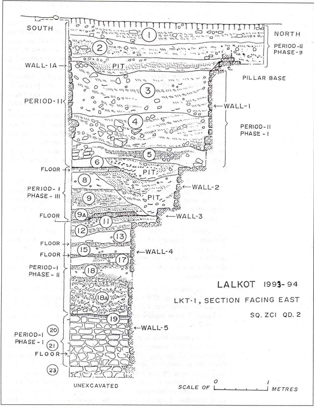
Excavations were then undertaken at Lal Kot area under the charge of B.R. Mani between 1991-92 and 1994-95. These revealed a sequence of two cultural periods:
Period I – Rajput Period (middle of 11th C to the end of 12th C)
Period II – Early Sultanate (end of 12th Cent to end of 14th C)
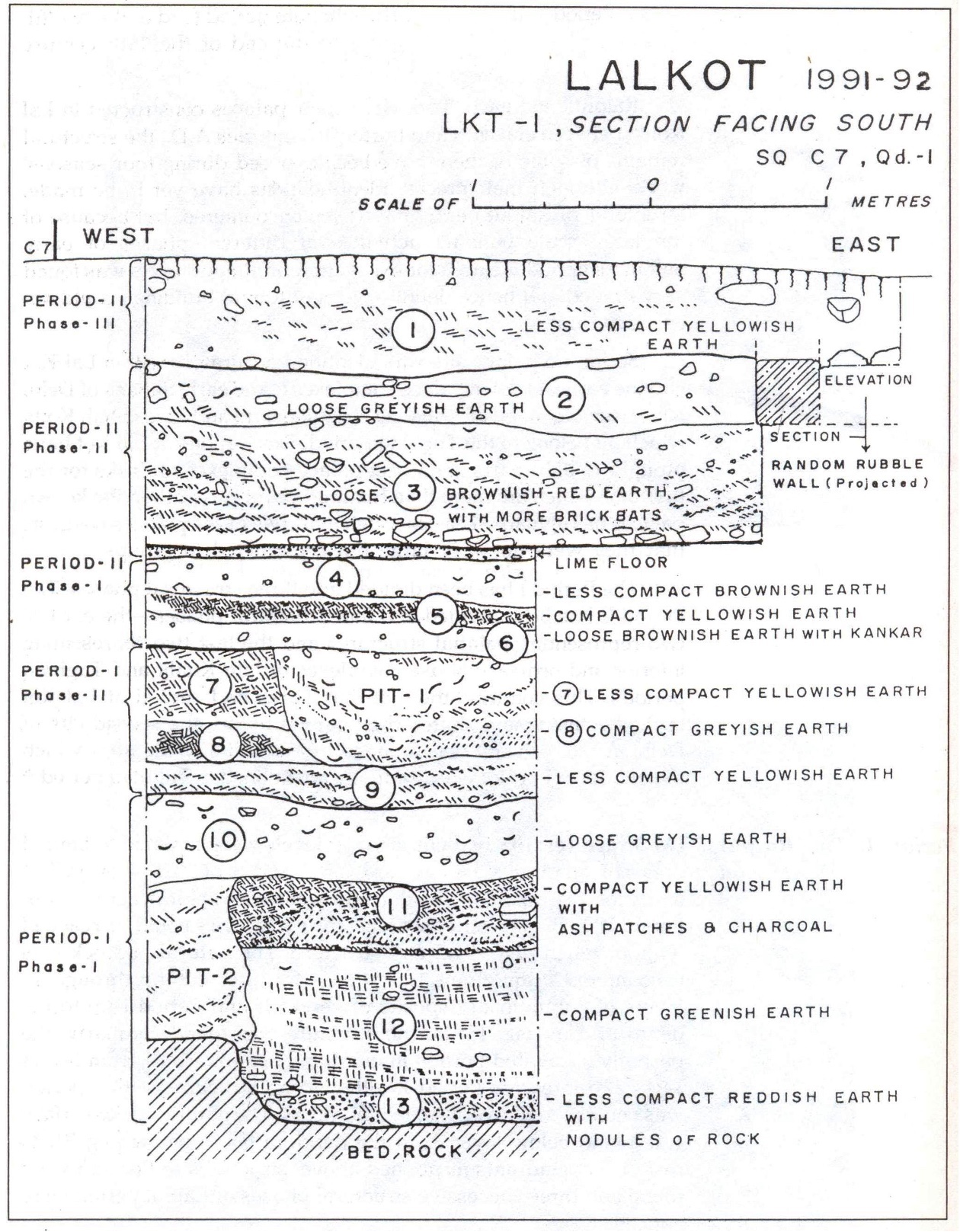
Period I was found divided into three structural phases all of which were generally represented by mud floors and rubble walls with medium sized stones set in mud mortar. In Phase III were encountered two floors of red murram and mud.
In this Period I one thus encounters either mud floors or mud floors mixed with lime finish. Two plastered drains were also noticed. At one spot remains of ochre painting were found over mud plaster on a wall. Ceramic industry included red ware, both plain and decorated. Black slipped grey ware were also encountered.
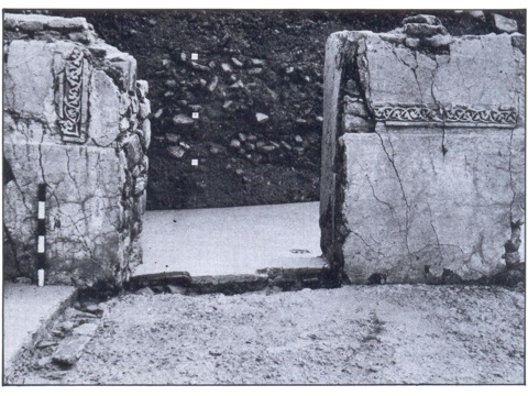
The Period II (Early Sultanate) is represented by four structural phases. Rooms with water cisterns and drains lined with lime plaster, Lime plastered water tanks and lime floors are encountered. In the succeeding phases, the drainage is covered with stone chips and fresh lime floor. ‘Rajput Style’ pillar bases, probably supporting wooden canopy are also found.
Another notable feature of this period is the use of brick-masonry for the construction of the water cistern, tank, small alcoves and the upper parts of the random rubble wall. All the structures have fine or decorated lime plaster, white in colour in which the decorated parts were probably painted with red colour. The structures were provided with fine lime floors. The ceilings were also probably provided with decorated lime plaster. The fragments of lime plaster of ceilings, decorated with undercut designs of flower were recovered from the debris.


The pottery of this Period II is also quite distinct. Glazed ware, both of sandy friable as also of ordinary terracotta core was profusely used. Foreign ceramics was another notable feature: (a) Chinese celadon ware; (b) fine quality of thin, monochrome & polychrome glazed ware; (c) some sherds of Chinese porcelain. Red ware and Grey ware are also encountered.
Shift Towards Yamuna and a ‘New City’:
It appears that the Dihli-i Kuhna (the Lal Kot / Qila Rai Pithora / Dhillika), the Old Delhi, along with the Hisar-i Nau (the New Fort) – the eastern extension of the Lal Kot – had a natural problem: the problem of water supply. It was situated 18 Km from the river. Dry wells have been excavated outside the Badaun Gate of Lalkot.
To rectify this issue, Sultan Iltutmish built the hauz-i Shamsi (Tabaqat-i Nasiri). Barani mentions that when in 1260’s the Meo’s rebelled, they obstructed the water-carriers and slave girls from filling water from the hauz-i sultani. From the Futuhat-i Firuzshahi we come to know that the channels feeding this tank also dired up as they were ‘dammed’ by ‘dishonest people’. Firuz Shah had to endeavour to get it back in working order.
According to Ibn Batuta, it was 2 mil long and one mil broad. However if you take its dimensions today, they are 200 metres by 125 metres. It is situated approximately 3 Km north of the Qutb complex. Probably, the difference is in the understanding of the term mil, which was definitely much shorter than the English mile. This tank fed with rain-water drained from the higher catchment areas on the ridge, was thus not enough to meet the requirements of the town.
Thus we find a gradual shifting of the city towards Yamuna. First a suburb, Ghiyaspur (during the reign of Ghiyasuddin Balban) developed. It was established near the khanqah of Nizamuddin Auliya. The distance between Ghiyaspur and the Dihli-i Kuhna was around 7 miles as the crow flies.
Between this settlement of Balban and the Yamuna, Balban’s successor Muizzuddin Kaiqubad, according to Zia Barani, built a walled palace (qasr), which was known as Kilokhari. According to Shaikh Nasiruddin (Khairul Majalis), it was half a kuroh (less than a mile) from Ghiyaspur. The palace was towards the river and between the two, Jalauddin Khalji is said to have laid out a garden. The Shahr-i Nau (the New City) developed during this reign around this palace.
According to Barani, the Sultan ordered the nobles and other great men to build their mansions and other large edifices in this area. Large markets were also established. And all this was surrounded with a great stone fortification. Its suburbs included areas around Indarpat and a place known as ‘Bakula’ where Mongols were settled – these areas were also known as Mughulpuri.
It was in 1952 that Olaf Prufer excavated Kilokhari {Report on the Trial Excavations carried out at Khilokhri, Delhi, 1952}
These excavations were conducted near the village Jogabai at a mound 100 × 100 m, having a height of 6 metres. They revealed two phases of structural activity at the site:
a. Pre-Tughluq: in which generally constructions of brick masonry are encountered; and
b. Tughluq: where we find constructions which are of stone masonry
From the excavations it also becomes apparent that the area was abandoned due to some invasion: thick ashy deposits mixed with unburied skeletal remains.
Glazed ware along with red ware, black slipped grey ware as well as ‘foreign ceramics in the form of Chinese pottery is also encountered.
Both Barani and Isami (Futuh us Salatin) inform us of ferocious Mongol invasions of Qutlugh Khwaja and Targhi Beg on Delhi.[ And then of course, the invasion ans sack of Delhi by the forces of Timur at the end of the Tughluq reign.] Thus Alauddin Khalji was forced to revert back to the rocky zone once again. To quote Barani:
The terror of the Mongols became all pervasive. Mughal horsemen began to come up to the Chabutara-i Subhani and the villages of Mori and Hadhi, and the banks of the hauz-i Sultani – after the disaster of Targhi’s invasion – which was a great disaster – Sultan Alauddin woke up from his sleep of negligence and gave up the projects of taking away the army on campaigns and reducing forts (in India). He now built his palace (kushak) in Siri and began to reside at Siri; he designated Siri his capital (darul khilafah) and made it well populated. He also built up the fort of Old Delhi.
Siri was in fact a plain wasteland (sahra) situated to the northeast of Shahr-i Kuhna.
Yazdi in his Zafarnama gives this directional information. Initially this settlement at Siri was called Lashkar or Lashkargah, army encampment or cantonment in contrast to the area around the Qutb which continued to be called the Shahr. Around 1317 AD, Nizamuddin Auliya in one of his recordings in Fawaid ul Fawad (Amir Ahmad Sijzi) comments on the distance between the Shahr and the Lashkar. A few years earlier, in 1314, Amir Ahmad Sijzi had a house built at Lashkar and used to pray in the Jama Masjid of Kilokhari. It was only around 1318 that Lashkargah (Siri) came to be nomenclated as Darul Khilafah, a fact which is corroborated by Ibn Batuta and Zia Barani.
The area of Siri was first identified by Cunningham who identified it with a vast area enclosed by raised mounds of earth near the village Shahpur Jat. The enclosed area is roughly 1.7 sq kilometres and aligns with what Yazdi described of Siri: it was a circular walled enclosure (sura). The main city however continued to be the area of the Qutb where Alauddin kept up his architectural projects: it was still the shahr, while Siri and Kilokhari were the Darul Khilafa and the shahr-i nau. The grand cloth market of Alauddin Khalji was located within the precincts of the Badaun Gate in the direction of Kushak-i Sabz. According to Barani it was known as Sara-i Adl. The grain market, the mandi, was situated near another gate of the city, the Mandvi Darwaza.
Further works to retain water were undertaken. The hauz-i sultani of Iltutmish was redug and resilted. Another tank, the hauz-i Alai or the hauz-i khas, about 2 miles north of the Qutb was dug. According to Carr Stephen it was square with each side measuring some 600 metres and a total space of 70 acres. Yazdi calls it as daryacha (a small sea) which would be filled during the rainy season and took care of the annual needs of the city inhabitants. The catchment area of this tank was the area now occupied by the IIT and the JNU where some of the channels are still visible.
Excavations at Siri were under taken by Raghbir Singh in 1976-77. They revealed the traces of the fortification walls built of undressed rubble laid in lime mortar. It was oval in plan with bastions at regular intervals. It further revealed single culture occupational deposit datable to early 14th Century
• Syed Ali Nadeem Rezavi
