
In the previous blog we saw what were the inspirations and sources for urban design. Now let us turn to the actual plan of the capital city of Akbar, initial orders to build which were given in 1571. In order to do so, we will be analysing a number of primary sources of the period.
Describing the plan of Fathpur Sikri, Abul Fazl writes:
A stone masonry fort (sangīn qila`) was erected and two stone-carved elephants at its gate inspired astonishment. Several noble buildings (kākh-hā) also arose in completion, and although the royal palace (daulatkhāna-i Shāhi) and the residences of many of the nobles are upon the summit of the hill (bar farāz-i koh), the plains (dasht wa sahra) likewise are studded with numerous mansions (manzil-ha) and gardens. By the command of His Majesty, a masjid, a madrasa and a khānqāh were also built upon the hill, the like of which few travellers can name. Adjacent to the town (piwast-i Shahr) is a reservoir (golābi), 12 kuroh in circumference, and on its embankments, His Majesty constructed a spacious courtyard (suffa) (lit. platform), mīnār and a chaugāngāh, where elephant fights are organized. In its vicinity is a quarry of red sandstone (sang-i surkh) whence columns and slabs of any dimensions can be excavated…. Under His Majesty’s patronage, carpets and fine stuffs are woven and numerous handicraftsmen have full occupation.
Arif Qandhari also points out that when in 1571 orders were issued to begin building Fathpur Sikri, the Emperor ordered:
… it (the shahr) is to have a two three kuroh circumference on the face of the earth and for houses (khāna-ha) to be built on the top of the hill and that they should lay out orchards (basātīn) and gardens (bāghāt) at its periphery and centre …. Trees were planted in the environs which had formerly been the habitat of rabbits and jackals, the mosques, markets (bāzār-ha), baths (hammāmāt), caravan sarais (kārwān sarā-ha) and other fine buildings (biqa`) were constructed in the city (shahr).
Arif Qandhari further writes that in 1576-77 the architects and engineers were ordered to:
…draw the picture (sūrat) of the city consisting of a wide rampart (sur) the circumference of whose wall is Akbarshāhi zira` (cubits)…. and the height of the wall from the foundation (bunyād) to the top of the battlements (shuraf) would be approximately thirty gaz. On the sides there are wide gateways (darvāz-ha). It is hoped that very soon it will be completed.
Fr. Monserrate, who visited the court of Akbar in 1580, also gives a very detailed account of the city. Describing the city, he writes:
It is placed on a spur of the mountain range which in former times was called, I believe, Vindius, [Vindhyas] and which stretches westward for a hundred miles towards Azmiris [Ajmer]. This site is rocky and not very beautiful, near to an old town which for this reason is called Purana Siquiris, [Purāni Sikri] (for Purana means ‘old’ in the vernacular and Siquiris is the name of the place). In the past nine years the city has been marvelously extended and beautified, at the expense of the royal treasury and the great nobles and courtiers, who eagerly follow the king’s example and wishes. The most noteworthy features of Fattepurum are, firstly, the king’s audience chamber, which is of huge size and very beautiful in appearance, overlooking the whole city: secondly, a great building supported on arches around which is a very spacious courtyard: thirdly, the circus where elephants fight, gladiatorial displays take place, and a game is played, on horseback, with wooden ball which is hit by hammers also of wood: fourthly, the baths, fifthly the bazar, which is more than half a mile long, and is filled with an astonishing quantity of every description of merchandise, and with countless people, who are always standing there in dense crowds.
Father Monserrate goes on to say:
… the citadel is two miles in circumference embellished with towers at very frequent intervals, though it has only four gates. The Agarena [Agra] Gate is to the East, the Azimirina [Ajmeri Gate] to the west, that of the Circus [Hathipol] to the north, and that of the Daulpurum [Dholpur Gate] to the south. The most striking of these is the Circus gate….
From these passages it becomes clear that (a) most of the Imperial structures and the houses of the influential sections of the nobility were on the top of the ridge;
(b) the civic population inhabited the areas below the ridge, where were also be located the gardens;
(c) the vicinity of the lake was adorned with pleasure resorts;
(d) there was a brisk commercial activity in the township;
(e) the town was oriented towards the lake where was situated the main gateway to the official area; and
(f) the whole town, along with its civic population, was placed within fortified walls.
Walls & Gates:
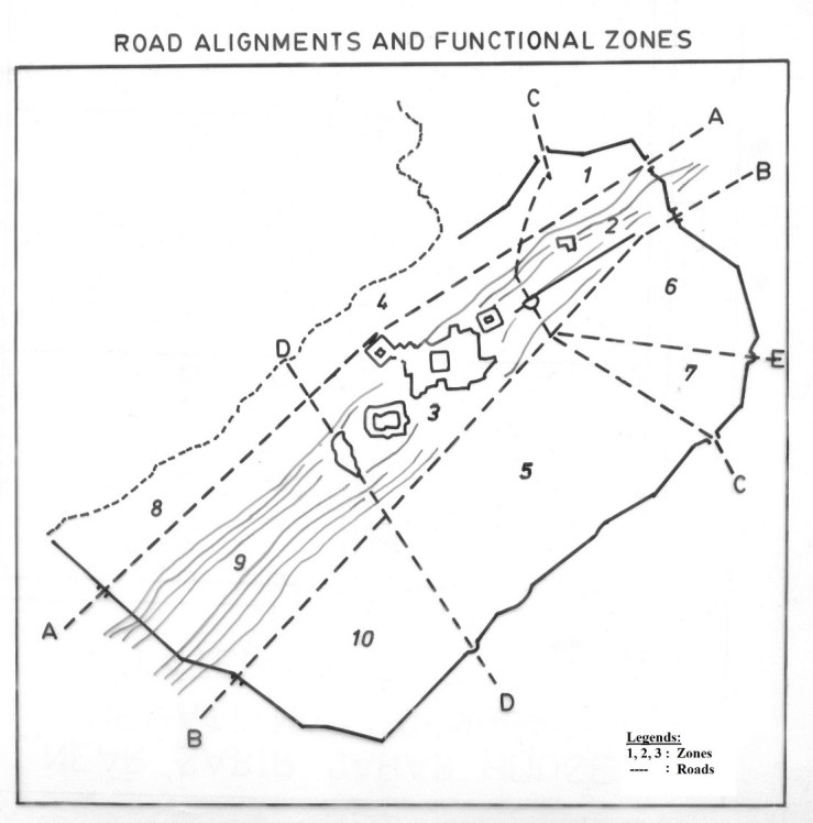
The fortification wall of Fathpur Sikri is provided with eight gateways to the city (see Plan II) starting from the west, the Ajmeri Darwaza, Tehra Darwaza, Dholpur/Gwalior Darwaza, Chandra Pol, Birbal/Bir Pol, Agra Darwaza, Lal Darwaza and the Dehli Darwaza.
Plan II
Constructed as gate-houses, they comprise an arched opening surround by porticos, guard rooms on the ground floor. Two external flights of steps, one on each side of the complex lead to galleries and rectangular chambers with centralized windows on the top. The arched openings are covered with low domed vaults. The Chandra Pol facing the east and Bir Pol facing south east appear to be less monumental in form than the other gates. The Ajmeri Darwaza, apart from being the grandest, appears to be unique in that the spaces above its arches are filled with rosettes inscribed with “Allah” in a beautiful hand. Each of the gate-house was flanked with a guard room which was situated to the left of the roads passing out of these gates.
As in the case of the Central Asian cities, where the walls encompassed not only the madīna or shahristān (the town proper with the palace), but the rabāt (the suburbs) as well , the city wall and gates of Fathpur Sikri contained within them not only the imperial quarters, and nobles’ houses but also habitation of the common population comprising merchants, traders, professionals and others. This would suggest a fairly close relationship between the political authority and the commercial classes.
Roads & Streets:
If one looks at the Plan II it would appear that the whole town was intersected by two horizontal roads, one (AA) running between Ajmeri Darwaza to the north-west and the Lal Darwaza to the north-east, and a second (BB) connecting Terha Darwaza, to the south-west, with Agra Darwaza in the south-east of the Palace. A branch of Road B branched off from the Agra Gate itself and went straight to the eastern opening of the Diwān-i Ām. Another two roads cut the township vertically. The Dehli Darwaza in the north-east was connected with Chandra Pol through road CC., while the Indarawali area towards the lake was joined with Gwalior Darwaza through DD. Another road (E) led from Birpol and joined BB just before the market area.
These roads were planned on a grid pattern and laid out with stone pieces dressed to wedge shape and set in mortar with their thinner ends projecting downwards. This setting allowed a smooth surface and gave stability and strength to the road. During the excavations it was found that the thickness or packing of the road varied between 5 cm to 50 cm. The main arterial roads (for example B: the road from Agra Gate to the Eastern gate of Diwan-i Am) were 15.40 m wide, with a packing thickness of between 34 and 50 cm.
There were a number of secondary roads which emanated from these arterial roads, which were approximately 3.6 m in width.
Excavations revealed four roads, each with secondary lanes, emanating at right angles from road ‘B’. One such road (Road CC in our Plan II.5) connected it with the Dehli Darwaza. It was constructed with rubble bound by thick lime mortar. A path near the eastern gate of the Diwan-i Am branched off from the main road and led to the structures constructed towards the south. This subsidiary road was 3.5 m wide with a 5.6 cm thick packing. Some portions of Roads ‘AA’ and ‘BB’ too, have survived. The stretch of Road ‘AA’ which survives (near the Indāra Ghāti) and a portion of Road DD (behind Indārāwāli Bāoli, portion on the spurs of the ridge) were located during our surveys conducted in March 1996 and July 1997. The surviving portion of Road AA is 4.36 m. and that of Road DD, 3.60 m in width.
Zones & Districts:
These intersecting roads divide the whole town into ten quarters, of which the central (Zone 3 of Plan II) was reserved for the Imperial establishments and bureaucratic offices. The area between roads AA, BB’ and CC (i.e. Zone 2 of the Plan II.5) was reserved for the higher nobility, while Zone 5 (between Roads, BB, DD & CC) was given to the ‘new’ township of Fathpur. The modern city of Fatehpur is also situated in the same zone.
In the open spaces towards the ramparts were located numerous gardens. Part of the old village of Sikri-Nagar, with its 13th-14th century monuments, was confined to Zone 1 (formed by roads CC & AA). Nagar, with its interesting Khalji mosques, lies outside the city walls, to the north of Zone 1. The Hiran Mīnar encircled with kārwān sarāis, Chaughan gāh, maidān etc. was located in Zone 4 (situated between the lake, and roads AA, DD & CC). Zone 8 (between roads AA & DD) and Zone 10 (between BB & DD) were mostly given to gardens and pleasure pavilions. Some residential structures were also located in Zone 8. Incidentally it was from this zone, the PGW and the associated wares, including the Sunga and Kushana artifacts were located.
Zone 9 can be divided into two districts, one on the top of the ridge, where a number of residential structures, hammāms, etc., are located, and the other, the Indāra Ghāti, where rows of gardens, pleasure pavilions and step-wells were situated. This area requires much closer attention than it has received so far.
The Īdgāh was placed to the west of the zone, outside the city walls. Zones 6 & 7 appear to have formed a single unit. The area, although devoid of standing structures, appears to have been reserved for the garrison, which might also have occupied certain quarters in zones 9 and 10 as well. Thus we see that the whole township was divided into eight functional zones by the interesting roads passing through its eight gates. These, probably, were further sub-divided into various districts by the subsidiary lanes and bye-lanes.
Grid Layout
The maxi grid of Petruccioli (based on that of Satish Davar) also divides the city into eight ‘squares’ .

The Maxi-Grid
This grid, as has been mentioned, is however based on gaz-i ilāhi, a unit of measurement which was introduced a year after Akbar had left Fathpur. (At the time Fathpur Sikri was built the gaz in use was the modified gaz-i sikandari. Before 1586-87, the gaz-i sikandari had a length of 30.36″.The gaz-i ilāhi on the other hand was 32.1 inches or 81.53 cm ).

In spite of this serious lapse, the middle vertical and the upper horizontal external segments of the modular grid traced by Petruccioli, intersect at the point where hiran minar is situated, which thus becomes the starting point for the maxi grid. This is logical. We have already seen that the hiran minar is not only located at the main entry point of the palace complex, but axially aligned with it.
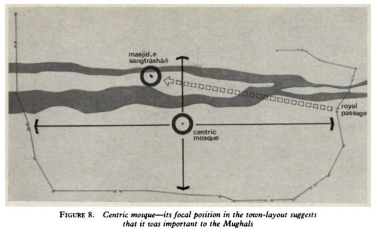
On the other hand, to Satish Davar the focal point of the town (and the grid) lay at a small mosque situated near the city market in the east. This small mosque, which Davar calls “Centric Mosque”, along with the Masjid Sangtarashan behind Akbar’s Jami Masjid acted as the focal position of the plan.

The ‘Centric Mosque’ & the ‘Cross
shaped’ Bazar
In accordance with the Mughal tradition of placement of functional zones around the Imperial court, exemplified by the standard plan of the Mughal Encampment explained by Abul Fazl, the Imperial palaces at Fathpur Sikri were surrounded by the various offices and bureaucratic establishments. The area adjoining the Imperial structures in the east, north and west appears to have been allotted for the buyutat/karkhanas or workshops. A few structures towards the south of the palace also reveal remains of a few structures identifiable as ‘offices’ or bureaucratic establishments (See Plan III).

Plan III
Bazars & Markets:
As in the case of other Central Asian towns (for example Balkh), the markets and shopping complexes at Fathpur Sikri were located between the Shahristān (the town proper with the palace and the bureaucratic establishments) and the rabāt (the suburbs comprising the houses of the general masses).
Our survey of Fathpur Sikri revealed five Akbari markets and at last four sarais which appear to have catered to the needs of the merchants visiting the markets. As in the case of London till the 18th century , the main shopping complex and commercial area at Fathpur Sikri was situated at a distance to the east within the city walls. In both the cities, the industrial area and artisans’ dwellings were located at the farthest point away from the Imperial quarters: the bulk of this area, in fact, was situated outside the city walls. At Fathpur Sikri, the areas of indigo cultivation, leather works, meat sellers etc. were situated either close to the city wall or outside of it. Our survey of a structure excavated by the ASI near the Dehli Darwaza revealed that it was an ironsmith’s cottage comprising two rooms and a masonry furnace.

Residential Areas:
Residential structures could not but be near the markets. There are at least two residential neighbourhoods within the town mentioned by our sources and one outside its walls. The first one of these is the ‘area of Salim Chishti’ also known as Shaikhpura or Nayabad, located behind the Jami’ Masjid and the other, the neighbourhood of Khwaja-i Jahan. The first was the area where the house and the old khānqāh of the Shaikh as well as other houses of the Chishti family and the Islam Khan Chowk were located. The second residential neighbourhood was that of ‘Khwāja-i Jahān’ where Mulla Abdul Qadir Badauni used to live.
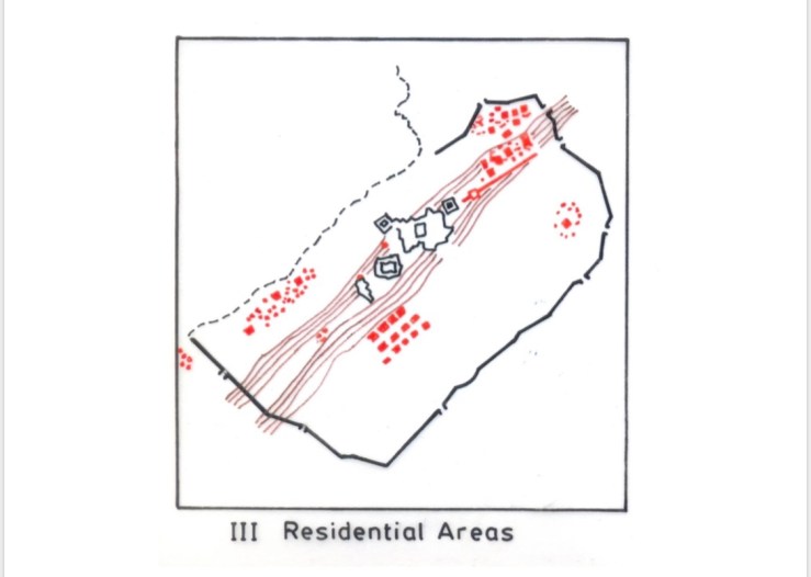
Outside the city walls was the neighbourhood inhabited by the prostitutes known as Shaitānpura (the Neighbourhood of Vice). We also hear of Khairpura, Dharampura and the Jogipura situated outside the city limits. But whether these were exclusive colonies / ghettos catering to the Shaikhs, Hindu poor and the mendicants or just structures to ‘feed’ the poor as Badauni alleges we do not know .
We have the testimony of Abul Fazl that the residences of the Akbari nobles were situated on the summit of the hill, while the other residential structures were situated below it in the plains.
Following the excavations by the Archaeological Survey of India and the team from the Centre of Advanced Study in History, Aligarh, it was found that a large number of noble’s structures were constructed on the northern ridge, between the so-called “Tansen Baradari” (near the Dak Bungalow of Lord Curzon) and the sarāi near the Agra Darwaza (Zone 2 in Plan II). The discovery of a marble tablet (sijdagāh) used by Shi`ites while praying, in one of the excavated structures in this area, suggests that this area was possibly inhabited by members of the Iranian nobility.
The second area where the nobility (according to Athar Abbas Rizvi, the Rajputs) had their residences was the Indārāwāli Ghāti (the Indārā Ghāti) area (Zone 8 and Zone 9 — section below the ridge, Plan II.5), situated between the ridge and the lake. The area, although now taken up by cultivated fields, is marked by a large number of gardens and a number of ruined structures. A massive mound, known popularly as ‘Matiya Mahal’, revealed during the course of our survey (July 1997), a massive complex comprising at least three courtyards with foundations of rooms all around them. Nothing more can be said regarding this structure until a detailed study is made possible by cleaning up the mound. It is located to the north-west of a large well known as the Indāra kuān, (from where an inscription of Babur has been taken) and south of the bank of the lake. A little to its south-west is another set of ruins known as the “Kalān Mahal”, comprising a residential structure and a hammām: the name is most probably a corruption of the term kalān mahal which stands for ‘great palace’.
The area also revealed extensive ruins of other houses, gardens, tanks and baths. Kale Khan, a local venerable guide and poet, testifies to the presence of a “Naumahla”, a multi-storeyed structure which was pulled down by his father in the early decades of this century. No trace of it is now extant. The area has spread over its surface a rich amount of painted blue China pottery sherds of very fine and medium fabric which give proof of the presence here of the richer strata of Mughal society.
The third area where the nobles had their houses was on top of the southern ridge (Zone 9) at some distance behind the Shaikh Ibrahim Mosque in the Nayabad Quarters. During one of our (July 1997) Surveys, the author encountered the ruins of residential structures and a hammām at a place where the modern cremation ground is located. A massive square tank (very similar to the Anup Talao in the daulatkhāna) with chambers all around it, is also located in this area. Unfortunately, the area is badly mutilated by stone-mining activity which is taking place in spite of an official ban imposed on it. A small narrow opening in the fortifications (Chor Khirki) towards this side connects this area with the old Mughal cemetery and Idgah outside the city walls. The Idgah and the cemetery have recently become the victim of illegal quarrying, and have been practically completely blasted away.
A fair number of Mughal residential structures (in ruins) and mosques still survive in the village of Sikri (Zone 1 and the district on the lower spurs of the ridge in Zone 2) and Fatehpur town (Zone 4). A large number of Vaishnavite, Shaivite and Jain idols, including those of the tīrthankaras of the 17th century, some of them now adorning the stone platforms in Sikri, have been located and discovered at Fatehpur, Nagar and Sikri, confirming the presence a sizeable non-Muslim population. Apart from the Khalji mosques, one trabeate street gate and extensive ruins of Akbari residential structures are encountered on the main road of Sikri. This and other areas are yet to be intensively explored.
Areas containing separately the votaries of vice and virtue, viz., the Shaitānpura (the district of prostitutes), the Jogipura (the settlements of jogis and pundits) and Shaikhpura (the quarters of the mullas) were all put outside the city limits.
Describing the “red-light” area outside the city limits, Badauni tells us that the Emperor appointed a number of bureaucratic officers and clerks in this “quarter”:
…so that any one who wished to associate with these people, or take them to his house, provided he first had his name and condition written down,might with the connivance of the imperial officers have connection with any of them that he pleased. But he did not permit any man to take dancing-girls to his house at night, without conforming to these conditions, in order that might keep the matter under proper control. But if any one wished to have a virgin, if the petitioner was a well-known courtier, he sent a petition by the Deputy, and obtained permission from Court.
Badauni further informs that a number of nobles including Raja Birbal who were caught breaking the code were reprimanded.
Pleasure Pavilions, Gardens & Water Supply:
The area around the periphery of the town as well as the banks of the lake was given over to pleasure pavilions, open fields and gardens. Within the township our surveys revealed at least 14 gardens apart from the three gardens in the palace complex and in a number of individual house structures. The demand for potable and irrigation water was taken care of by a number of baolis (step wells), tanks and wells dispersed all over the town.

Thus we see that the plan of Fathpur Sikri accords fairly well with that of the Imperial encampment described by Abul Fazl. It also duly takes into account the contours of the site: the main mosque and the Imperial palaces and offices were put on the ridge where water-supply was secured through lifting it by wheels from the lake, and having it carried by aqueducts.
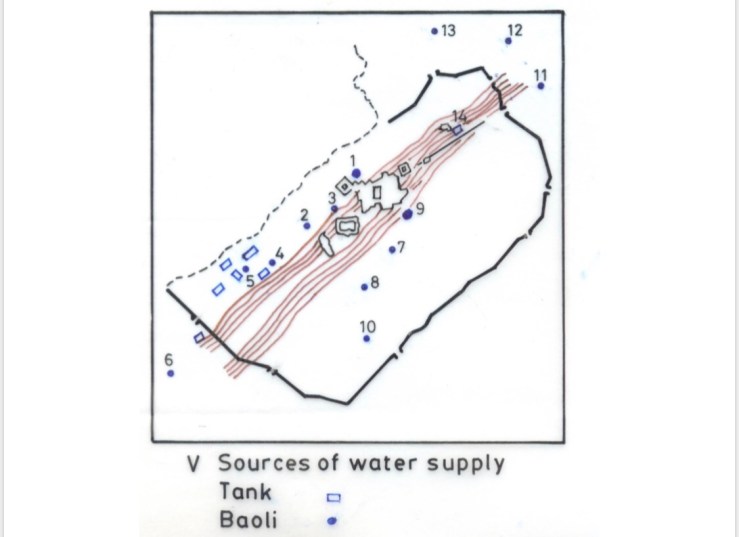
In the plains on both sides where the lake and wells could directly give access to water, the civil population had its quarters assigned, the nobility and the lower strata being well separated. The planned construction of shops on long avenues (see infra), built obviously at Imperial expenditure, and then presumably leased out to private shop-keepers is a very notable feature of the planned city; as is the construction of the caravan sarais, built again under Imperial aegis, to accommodate merchants and travellers. Not only was Fathpur Sikri, then, well planned; there was also a considerable investment of imperial resources in it, to ensure that it fulfilled its proper functions as an Imperial town of a new Empire.
Copyright Syed Ali Nadeem Rezavi
Extracts from Fathpur Sikri Revisited (OUP) 2013
https://global.oup.com/academic/product/fatehpur-sikri-revisited-9780198084037?cc=us&lang=en&