MODELS AND THEORIES OF URBAN DESIGN:
The study of planning and building a city during the seventeen century, and the sources and determinants of its urban designs has perhaps yet to receive adequate attention.
The students of urban planning have put forward a number of ‘models’ of planning. Traditionally three models, namely
(a) the European,
(b) the ‘Islamic’ and
(c) the ‘Hindu’
All these three have been put forward as alternative models.
On a closer analysis of these, it appears that there is hardly any difference between them — in all the three, the central place is given to the palace or citadel and the place of worship.
The Shilpa-śāstra (especially the vāstu puruśa mandala) on the other hand categorise the town models on the basis of their physical pattern. Thus according to this categorisation there were towns which were either
(a) Circular,
(b) Crescent or half-moon,
(c) Cross,
(d) Square, or
(e) rectangular.

In each of these ‘models’ as well, the citadel along with the public buildings and the main place of worship is placed at the centre with roads from all sides leading to them. Attention was concentrated on the citadel which was the seat of power. All around it was the fortification; the rest of the city was generally left defenceless and unfortified.
In the recent years, yet another theory of urban design has been put forward for Mughals. Basing himself on the description of the genesis, organization, and decline of the ‘patrimonial’ states formulated by Max Weber , Stephen Blake distinguishes between the European capital cities and the sovereign cities of the Asian Empires, and goes on to show how Shāhjahānabād, the Mughal city of Delhi evolved and developed as a city of the latter type.
The Asian empires, according to him were “patrimonial -bureaucratic empires”, the controlling metaphor of which was the patriarchal family and the “central element” was the imperial household.
According to this thesis, the capital was an enormously extended household. At the macro-level, it was a miniature version of the kingdom. The palace-fortress stood for the city, and the mansions of great nobles for the provinces, districts and other subdivisions of the state. The various mansions, mosques, shops and gardens in the city were elaborations and copies of the buildings of the palace complex. In other words, the capital city in the “Asian Empires” was nothing but the extension of the Imperial household where everyone was bound by personal ties with the emperor who presided over the city — and the whole kingdom — as a father over his sons. The markets, the production relations, the cultural life and every thing else including the process of consumption were all dominated by the great households.
What this in effect meant was what was offered in the Weberian argument that the non-western cities did not generate the same degree of urban autonomy as may be found in the West. These non-Western cities neither achieved significant measures of municipal self-government, nor produced city dwellers conscious of themselves as a distinct class or social group.
Does this model of the city in “Asian Empire” apply to Fathpur Sikri?
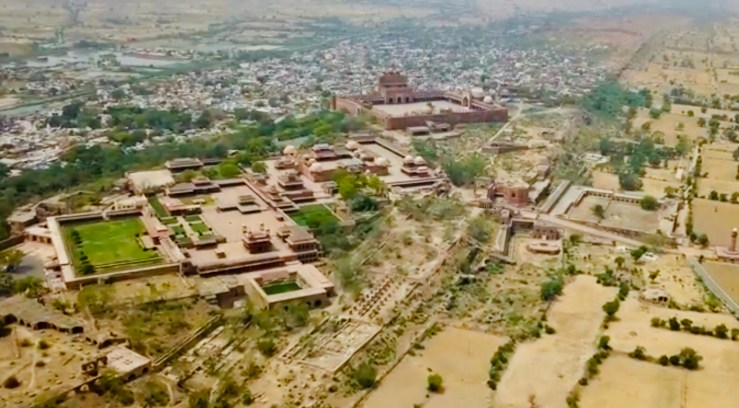
Our surveys in fact go out to reject this Weberian thesis. Although having a strong centralizing basis, Fathpur Sikri appears to be no different than London of the pre-Industrial Revolution era as far as the placements of its functional elements are concerned. Its colossal hydraulic works for water-supply, the efficient well-planned roads, streets and bye-lanes and the presence of a large number of monumental gardens, sarāis and well defined suburbs, point to the desire of the Mughal architects to not only redesign the urban landscape but also to provide for public services. The fact that the Mughal towns, including the Imperial cities were flourishing centres of commerce and crafts is not only attested to by the archaeological remains or deductions based on comparisons with European and colonial cities, the contemporary sources and authorities also help to underline this fact. Fathpur Sikri even after it ceased to be an Imperial town survived as an important commercial centre.
Depending on its size, a town in Mughal India was classified as (a) balda or shahr, and (b) qasba. While the qasba was a township, the shahr/balda was a big city.
Whether a balda or a qasba, a typical medieval city had a number of features common to all urban settlements. Containing a civic population which was largely non-agricultural, the city was surrounded by an outer wall (fasīl) and/or a deep trench.
For Western Europe we know that the term ‘town’ or ‘burg’ appear to have been derived originally from names for large areas enclosed by fortifications which served as places of “refuge during wars.” Robert Lopez, thus symbolized the notion of the city as “the cross” or “cross roads” within the “walls”.
This notion suggests a combination of protected social space and intercommunication between those coming from different directions to the crossroads of urban life. Now if we look at the different “Asiatic” cities and Imperial towns we find that almost all these towns were either protected by a fortification or a deep trench encompassing the inhabited areas. Dealing with Trans Oxiana and surrounding regions, Barthold mentions the walls with a number of gates encompassing the towns and suburbs in Balkh, Bukhara and Samarqand.
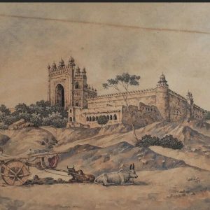
In the Mughal cities, the towns were usually protected by thick walls with battlements, string-courses and towers. Lahore, Ahmadābād, Broach, Baroda, Cambay, Sūrat, Shāhjahānābād and Fathpur Sikri were all walled cities. Ajmer, Multan, and Koil (modern Aligarh) are examples of cities which had both walls and a deep trench encircling them. Agra and Ujjain on the other hand were towns with no city walls. Agra was protected only with a deep trench. It was only during the 18th century that walls were constructed around these cities.

SOURCES AND INSPIRATIONS OF URBAN DESIGN:
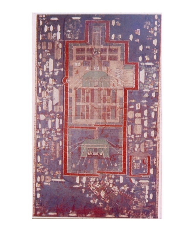
The Mughal emperors being often on the move, the traditional plan of the Mughal Encampment appears to have been the principal inspiration for the Mughals, when they built their towns. Being one of the first organized towns to develop, Fathpur Sikri appears to have drawn on the various principles used in setting up of such camp cities. Even the vocabulary applied by the Persian sources to describe the permanent stone structures is often the same as was used for the temporary portable dwellings. The public audience hall (now called Dīwān-i Ām) is sometimes referred to as bārgāh-i Ām (the large audience tent), the sleeping or retiring room (khwābgāh) of the emperor as khilvat kada-i khās (the tent of privacy), the haram (female quarters) as Sarāpardā, Sarāpardā-i ismat (the screened-in area of Chastity), Shabistān-i daulat (the Imperial bed-chamber or haram) or Shabistān-i Iqbāl, (The Bed-Chamber of Good Fortune or haram), such being the names also of different categories of tents.
Explaining the plan of a Mughal Imperial encampment, Abul Fazl writes:
They pitch the Shabistān-i iqbāl [the haramsarā], the daulatkhāna [the Imperial palace or quarters] and the Naqqārkhāna [the drum house] all within a distance of 1530 gaz (yards). To the right and left of these, and behind them, an open space of 300 yards is reserved for guards. Within the principal enclosure, at a distance of 100 yards from the centre, are pitched the tents of Maryam Makāni (Akbar’s mother), Gulbadan Begum (Akbar’s sister), other chaste ladies, and the tents of Prince Daniyal; to the right, those of Prince Sultan Salim; and to the left, those of Prince Shah Murad. Behind the tents, at some distance, the buyūtāt [kārkhānās or workshops] are placed; and at a further distance of 30 yards behind them, at the four corners of the camp, the bazars (the markets). The nobles encamped on all sides, according to their rank, outside the complex reserved for the Imperial use.
According to this scheme the central area was reserved for Imperial use, flanked by the princes’ area which was surrounded by that of the nobility. Beyond this zone, on the sides were the service areas. The markets were situated at the corners. Secondly, there was a hierarchical progression from the public to the private areas.

Satish Davar was the first to point out that, irrespective of the topography, the Mughals tended to reproduce the same scheme as that of the Encampment in their permanent palace-complexes so as to make a veritable stone encampment. Athar Abbas Rizvi also assumed that there was a similarity between the layout of the Mughal camp and the plan of Fathpur Sikri. It was on the basis of this assumption that he tried to look for the Prince’s quarters and noble’s houses in the areas outside and around the main palace.
If we compare the structure composing the Imperial camp as explained by Abu’l Fazl, a number of parallels can be drawn. While on the move, the Emperor would stay in a portable double-storied pavilion (kākh-i du Āshiyāna) within the eastern corner of a cloth-covered wooden screen known as Gulālbār. Adjoining the du-āshiyāna, within the same enclosure (sarāpardah) was a chobīn rāvati, a wooden structure. The jharokha was provided in the du-āshiyāna, which was also the pavilion where the king would perform his prayers, and the nobility performed kūrnish (bowing) before him.
Between the area of daulatkhāna-i khās (the Emperor’s personal encampment) and the women’s quarters was left an open area known as māhtābi, in the middle of which was a platform (suffa) which was protected by a namgīrah (awnings) supported by four poles. This is where the Emperor would sit during the evenings.
Within the sarāparda-i ismat or the women’s enclosure were raised 24 wooden rāvatis, adjoining which was yet another enclosure, 60 gaz square, meant for Urdubēgis or armed women guards and other female servants.
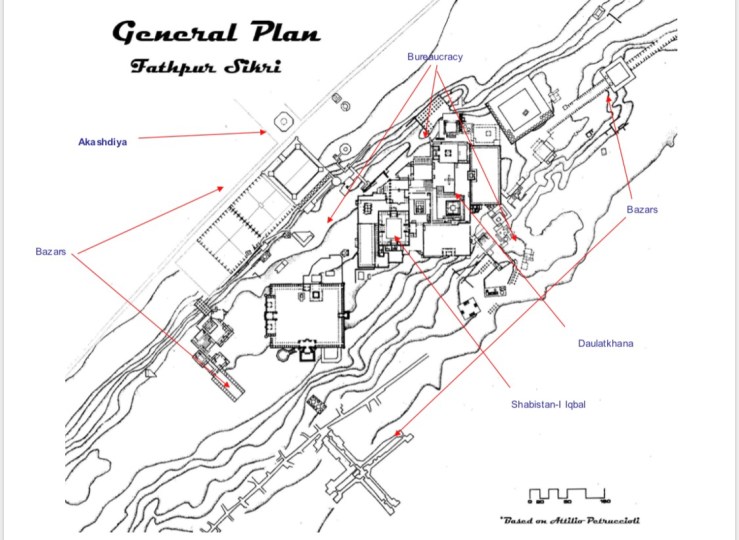
Another enclosure comprised the bārgāh or the court which had 72 rooms and two openings. Outside the enclosures of shabistān-i iqbāl (women’s enclosure), the bārgāh and daulatkhāna (Imperial quarters) was placed an enclosure used as dīwānkhāna-i khās beyond which stood the Ākāshdiya (lamp bearing pole).
Interestingly at Fathpur Sikri, within the enclosure of the daulatkhāna, to the east is the double storied building which must be the khwābgāh in which the Emperor slept and offered jharokha darshan (morning public appearance). Within the same enclosure, at a little distance from this khwābgāh, is a structure comprising a chamber raised on a platform, which has been explained as Ābdārkhāna (Water Stores). Between the haramsara and daulatkhāna area is constructed a four-platformed structure surmounted with a chhatri (cupola) raised on four pillars, the so-called ‘Panch Mahal’. The affinity between this stone structure and its placement vis-a-vis the suffa or platform of the camp is too close to escape attention. Like the sarāparda-i ismat or Shabistān-i iqbāl, the haram sara area at Fathpur Sikri had a rectangular enclosure beyond the main buildings, which was probably meant for the female guards.
Although Abu’l Fazl does not mention it, it appears that in the Timurid tradition the Imperial camps were aligned on a north-south axis. Secondly, in the Mongol tradition there was a left-right hierarchy with southward orientation —the west being on the right-hand side, so that the king could be seated facing south. Both these axes are found at Fathpur Sikri. Sitting on the jharokha window, Akbar faced the south with his daulatkhāna behind to the north. Further north was the Naqqārkhāna and the Ākāsh diya, the Hiran Minār. To his right (the west) was the Tomb of Salim Chishti, the Jami‘Masjid and the Ibādatkhāna.
Alina Macneal, holding the view that Fathpur Sikri was based on the Timurid plan of encampment, however opines that at Fathpur Sikri due to the topography of the site, the camp’s single north-south axis was broken into two constituents: the axis of progression from public to private and the axis of royal appearance. The axis of progression was laid out from north-east to north-west, aligning Dīwān-i Ām, daulatkhāna and haramsara. The main ceremonial access to the Emperor’s sight was obtained by an opening from Hāthipol to Khwābgāh, on a north-south axis. Further, like a Mughal encampment, the language of the palace at Fathpur was one of pavilion and enclosure. Large spaces alternated with stone pavilions.
As in an Encampment, we find that the palace was surrounded by rings of bureaucratic establishments, nobles’ houses and habitations of the common people. The markets were constructed in a linear fashion along the sides.
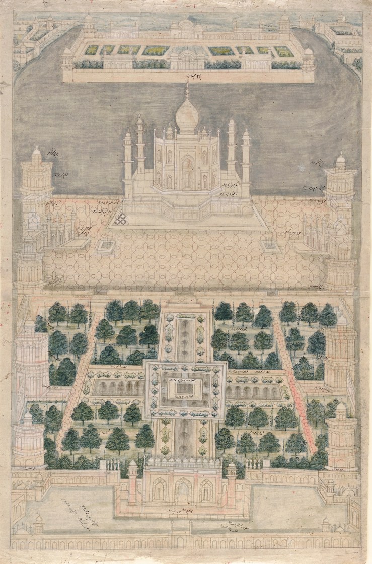
Another possible source of its design appears to have been the Mughal-garden, the Chahārbāgh. According to Petruccioli, the centripetal symmetry of the chahārbāgh could be an inspiration for the Mughal urban design. The axes, joints and nodules of a garden were turned architecturally into pavilions, the chabutaras, waterfalls, pools, kārwān sarāis and symmetrical roads. Thus it was the modular grid which became a systematic design instrument. The town was divided into various distinct divisions revolving around a localized central structure on the one hand, and aligned symmetrically with the main centre, on the other.

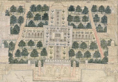

Bāgh i Fath
For the individual structures and buildings, the inspiration came from a number of traditions. By the time Fathpur Sikri began to be constructed, the traditions of Rajput and Gujarat architecture had already been incorporated in the buildings of the pre-Mughal Muslim rulers of India. At Fathpur Sikri the dominant influence appears to be that of the Timurid and Gujarati Sultanate Architecture. In a number of structures at Fathpur Sikri the central vaults over the chambers are masked by a flat roof. This may at one level be a combination of the structurally arcuate (the ‘Saracen’ or Delhi Sultanate style) with the visibly trabeate (recalling the attractive Gujarat Sultanate style). We have this example in the Khwābgāh, the Emperor’s seat in the Diwān-i Ām, the ‘Daftarkhāna’, the ‘Tansen bārādari’, ‘Todarmal’s bārādari, ‘Hādā Mahal’, ‘Qūshkhāna’ and the city gateways. The vaults consisting of four large intersecting ribs, which create a central vaulted area, four squinches and four rectangular fields are mostly found in the hammāms.
The most typical example is that of the so-called ‘Hakim’s Baths’ (the Imperial hammām). Central Asian features are also encountered in the other hammāms, kārwānsarāis and pavilions on top of palace buildings where Timurid masonry vaults form the ceilings. The Rang Mahal and complexes around it (Petruccioli’s Badi‘ Mahal), the four-storied pavilion erroneously known as ‘Panch Mahal’, and the ‘Hawa Mahal’ adjoining the haramsara are all based on the Iranian and Timurid post-and-beam porches.
In Iran such structures were known as tālār and in Trans Oxiana as Aiwān. The Trabeate construction of these structures is marked by a strong sense of weight and measure. The sense of heaviness encountered in the construction of the palace of Mahmud Begra at Sarkhej and the Nagina Mahal at Khimlassa Fort (15th C. A.D) is overcome here. Geometrical precision appears to be the hall-mark of Akbari structures.
In the so-called ‘Birbal’s palace, the Buland Darwaza, and the Hathipol, arcuate and trabeate styles have been followed in equal proportions. Echoes of wooden architecture are also encountered — the ceilings of the hujra-i Anūptalāo (Turkish Sultana’s house) and the Chahārkhāna (“Ānkhmichauli”), the pillars of the Rang Mahal and the so-called Badi‘ Mahal all remind us of wooden structures.


Extracts from
https://global.oup.com/academic/product/fatehpur-sikri-revisited-9780198084037?cc=us&lang=en&

Copyright: Syed Ali Nadeem Rezavi
